
LAND DEVELOPMENT CODE Chapter 2
Zoning Regulations
____________________________________________________________________________________
CHAPTER 2
ZONING REGULATIONS
2.00.00 PURPOSE .......................................................................................................................... 2-5
2.00.01 ZONING REGULATIONS ............................................................................................ 2-5
2.00.02 CONFLICT WITH COMPREHENSIVE PLAN ............................................................. 2-5
2.00.03 RELATIONSHIP TO FUTURE LAND USE MAP CATEGORIES ................................ 2-5
2.00.04 OFFICIAL ZONING MAP............................................................................................. 2-7
2.01.00 AGRICULTURE DISTRICT ............................................................................................... 2-8
2.01.01 Purpose ........................................................................................................................ 2-8
2.01.02 Intent ............................................................................................................................ 2-8
2.01.03 Location/Designation Guidelines .................................................................................. 2-8
2.01.04 Permitted Uses ............................................................................................................. 2-8
2.01.05 Special Exceptions ..................................................................................................... 2-11
2.01.06 Bulk Regulations ......................................................................................................... 2-12
2.02.00 RESIDENTIAL RURAL DISTRICT .................................................................................. 2-13
2.02.01 Purpose ...................................................................................................................... 2-13
2.02.02 Intent ......................................................................................................................... 2-13
2.02.03 Location/Designation Guidelines ................................................................................ 2-13
2.02.04 Permitted Uses ........................................................................................................... 2-13
2.02.05 Special Exceptions ..................................................................................................... 2-14
2.02.06 Bulk Regulations ......................................................................................................... 2-15
2.03.00 RESIDENTIAL – 1 DISTRICT ......................................................................................... 2-16
2.03.01 Purpose ...................................................................................................................... 2-16
2.03.02 Intent ........................................................................................................................... 2-16
2.03.03 Location/Designation Guidelines ................................................................................ 2-16
2.03.04 Permitted Uses ........................................................................................................... 2-16
2.03.05 Special Exceptions ..................................................................................................... 2-16
2.03.06 Bulk Regulations ......................................................................................................... 2-17
2.04.00 RESIDENTIAL – 2 DISTRICT .......................................................................................... 2-18
SUBURBAN RESIDENTIAL DISTRICT ........................................................................... 2-18
2.
04.01 Purpose ...................................................................................................................... 2-18
2.04.02 Intent ........................................................................................................................... 2-18
2.04.03 Location/Designation Guidelines ................................................................................ 2-18
2.04.04 Residential 2 - Permitted Uses ................................................................................... 2-18
2.04.05 Suburban Residential - Permitted Uses ..................................................................... 2-18
2.04.06 Special Exceptions ..................................................................................................... 2-18
2.04.07 Bulk Regulations ......................................................................................................... 2-19
2.05.00 RESIDENTIAL – 3 DISTRICT .......................................................................................... 2-20
2.05.01 Purpose ...................................................................................................................... 2-20
NOTE: FOR OKALOOSA ISLAND CODES
B-1, B-2, B-3, & B-4 CLICK HERE!

LAND DEVELOPMENT CODE Chapter 2
Zoning Regulations
____________________________________________________________________________________
2.05.02 Intent ........................................................................................................................... 2-20
2.05.03 Location/Designation Guidelines ................................................................................ 2-20
2.05.04 Permitted Uses ........................................................................................................... 2-20
2.05.05 Special Exceptions ..................................................................................................... 2-20
2.05.06 Bulk Regulations ......................................................................................................... 2-21
2.06.00 MANUFACTURED/MOBILE HOME PARK DISTRICT ................................................... 2-22
2.06.01 Purpose ...................................................................................................................... 2-22
2.06.02 Intent ........................................................................................................................... 2-22
2.06.03 State Permit Required ................................................................................................ 2-22
2.06.04 Location/Designation Guidelines ................................................................................ 2-22
2.06.05 Permitted Uses ........................................................................................................... 2-22
2.06.06 Special Exceptions ..................................................................................................... 2-22
2.06.07 Bulk Regulations ......................................................................................................... 2-23
2.07.00 MIXED USE DISTRICT ..................................................................................................... 2-23
2.07.01 Purpose ...................................................................................................................... 2-23
2.07.02 Intent ........................................................................................................................... 2-23
2.07.03 Location/Designation Guidelines ................................................................................ 2-23
2.07.04 Permitted Uses ........................................................................................................... 2-23
2.07.05 Special Exceptions ..................................................................................................... 2-25
2.07.06 Approval Procedure .................................................................................................... 2-25
2.07.07 Bulk Regulations ......................................................................................................... 2-25
2.07.08 development Criteria .................................................................................................. 2-25
2.07A.00 MIXED USE 1 & 2 DISTRICTS ...................................................................................... 2-26
2.07A.01 Mixed Use – 1 .......................................................................................................... 2-26
2.07A.02 Mixed Use – 2 .......................................................................................................... 2-26
2.08.00 BUSINESS OFFICE DISTRICT [C-1] .............................................................................. 2-27
2.08.01 Purpose ...................................................................................................................... 2-27
2.08.02 Intent ........................................................................................................................... 2-27
2.08.03 Location/Designation Guidelines ................................................................................ 2-27
2.08.04 Permitted Uses ................................
........................................................................... 2-27
2.08.05 Special Exceptions ..................................................................................................... 2-27
2.08.06 Bulk Regulations ......................................................................................................... 2-28
2.09.00 NEIGHBORHOOD COMMERCIAL DISTRICT [C-2] ....................................................... 2-29
2.09.01 Purpose ...................................................................................................................... 2-29
2.09.02 Intent ........................................................................................................................... 2-29
2.09.03 Location/Designation Guidelines ................................................................................ 2-29
2.09.04 Permitted Uses ........................................................................................................... 2-29
2.09.05 Special Exceptions ..................................................................................................... 2-30
2.09.06 Bulk Regulations ......................................................................................................... 2-30

LAND DEVELOPMENT CODE Chapter 2
Zoning Regulations
____________________________________________________________________________________
2.10.00 GENERAL COMMERCIAL DISTRICT [C-3] ................................................................... 2-31
2.10.01 Purpose ...................................................................................................................... 2-31
2.10.02 Intent ........................................................................................................................... 2-31
2.10.03 Location/Designation Guidelines ................................................................................ 2-31
2.10.04 Permitted Uses ........................................................................................................... 2-31
2.10.05 Special Exceptions ..................................................................................................... 2-33
2.10.06 Bulk Regulations ......................................................................................................... 2-33
2.10.07 Performance Criteria .................................................................................................. 2-33
2.11.00 AIRPORT COMPATIBILITY DISTRICT ........................................................................... 2-35
2.11.01 Purpose ...................................................................................................................... 2-35
2.11.02 Intent ........................................................................................................................... 2-35
2.11.03 Location/Designation Guidelines ................................................................................ 2-35
2.11.04 Permitted Uses ........................................................................................................... 2-35
2.11.05 Allowable Density ....................................................................................................... 2-35
2.11.06 Bulk Regulations ......................................................................................................... 2-36
2.12.00 INDUSTRIAL DISTRICT [I-1] .......................................................................................... 2-37
2.12.01 Purpose ...................................................................................................................... 2-37
2.12.02 Intent ........................................................................................................................... 2-37
2.12.03 Location/Designation Guidelines ................................................................................ 2-37
2.12.04 Permitted Uses ........................................................................................................... 2-37
2.12.05 Special Exceptions ..................................................................................................... 2-38
2.12.06 Bulk Regulations ......................................................................................................... 2-38
2.13.00 AIRPORT INDUSTRIAL PARK DISTRICT [1-2] ............................................................. 2-39
2.13.01 Purpose ...................................................................................................................... 2-39
2.13.02 Intent ........................................................................................................................... 2-39
2.13.03 Location/Designation Guidelines ................................................................................ 2-39
2.13.04 Permitted Uses ........................................................................................................... 2-39
2.13.05 Special Exceptions ..................................................................................................... 2-39
2.13.06 Bulk Regulations ......................................................................................................... 2-40
2.
14.00 INSTITUTIONAL DISTRICT ............................................................................................. 2-41
2.14.01 Purpose ...................................................................................................................... 2-41
2.14.02 Intent ........................................................................................................................... 2-41
2.14.03 Location/Designation Guidelines ................................................................................ 2-41
2.14.04 Permitted Uses ........................................................................................................... 2-41
2.14.05 Density/Intensity Standards ........................................................................................ 2-42
2.15.00 RECREATION DISTRICT ................................................................................................. 2-43
2.15.01 Purpose ...................................................................................................................... 2-43
2.15.02 Intent ........................................................................................................................... 2-43
2.15.03 Location/Designation Guidelines ................................................................................ 2-43
2.15.04 Permitted Uses ........................................................................................................... 2-43

LAND DEVELOPMENT CODE Chapter 2
Zoning Regulations
____________________________________________________________________________________
2.15.06 Bulk Regulations ......................................................................................................... 2-43
2.16.00 RESERVED ...................................................................................................................... 2-44
2.17.00 SCHEDULE OF BULK REGULATIONS .......................................................................... 2-45
2.18.00 RESIDENTIAL DESIGN ALTERNATIVES ..................................................................... 2-50
2.18.01 Purpose ...................................................................................................................... 2-50
2.18.02 Design Alternatives ..................................................................................................... 2-50
2.18.03 Cluster Subdivisions ................................................................................................... 2-50
2.18.04 Zero-Lot-Line Development ........................................................................................ 2-50
2.18.05 Z-Lots and Angled Z-Lots ........................................................................................... 2-51
2.18.06 Zipper Lots .................................................................................................................. 2-51
2.19.00 BULK REGULATIONS FOOTNOTES ............................................................................ 2-52
2.20.00 SPECIAL USES ............................................................................................................... 2-54
2.20.01 Alcoholic Beverage Establishments .......................................................................... 2-54
2.20.02 Animal Hospitals; Veterinary Clinics; Commercial Kennels and
Businesses that board animals ................................................................................................ 2-56
2.20.03 Cemeteries ................................................................................................................ 2-56
2.20.04 Churches and Other Religious Institutions ................................................................. 2-56
2.20.05 Public Schools and Other Public Institutions ............................................................. 2-57
2.20.06 Private Airports; Residential Airparks ......................................................................... 2-57
2.20.07 Dog Friendly Dining Establishments .......................................................................... 2-58
2.20.08 Tall Structures ........................................................................................................... 2-61
2.20.081 Towers and Telecommunications Facilities.............................................................. 2-61
2.20.082 Residential ................................................................................................................ 2-67
2.20.083 Exemption ................................................................................................................. 2-67
2.20.084 Okaloosa Island ........................................................................................................ 2-68
2.20.09 Aircraft Restricted Zone .............................................................................................. 2-68
2.20.10 MEDICAL MARIJUANA
DISPENSARIES
.................................................................... 2-70
2.21.00 ACCESSORY USES AND STRUCTURES ...................................................................... 2-71
2.21.00 Purpose ...................................................................................................................... 2-71
2.21.01 Applicability ................................
................................................................................. 2-71
2.21.02 Residential Accessory Uses and Structures .............................................................. 2-71
2.21.03 Nonresidential Accessory Uses and Structures ......................................................... 2-72
2.21.04 Agriculture Accessory Uses and Structures ............................................................... 2-73
2.21.05 Limitations and Restrictions........................................................................................ 2-73
LAND DEVELOPMENT CODE Chapter 2
Zoning Regulations
____________________________________________________________________________________
2-5
2.00.00 Purpose: The purpose of this chapter is to implement and put into practical regulatory effect the
provisions of the Future Land Use Element and future land use categories established in the Okaloosa
County Comprehensive Plan.
2.00.01 Zoning Regulations: Zoning districts, classifications, and regulations are hereby established as
sections 2.01.00 through 2.21.00 of this code. All development or use of land within the unincorporated
area shall be in accordance with the regulations specified herein. Zoning districts to be depicted on the
Official Zoning Map are as follows. Go here for SCHEDULE OF BULK REGULATIONS
(density,
setbacks, minimum lot frontage, maximum building height, Impervious Surface Coverage (ISC) and Floor
Area Ratio (FAR)
AGRICULTURE (AA)
RESIDENTIAL RURAL (RR)
RESIDENTIAL -1 (R-1)
RESIDENTIAL -2 (R-2)
RESIDENTIAL -3 (R-3)
SUBURBAN RESIDENTIAL (SR)
MANUFACTURED/MOBILE HOME PARK (MHP)
MIXED USE (MU)
MIXED USE - 1 (MU-1)
MIXED USE -2 (MU-2)
BUSINESS OFFICE (C-1)
NEIGHBORHOOD COMMERCIAL (C-2)
GENERAL COMMERCIAL (C-3)
AIRPORT COMPATIBILITY .5 (AC-.5)
AIRPORT COMPATIBILITY 1 (AC-1)
INDUSTRIAL (I-1)
AIRPORT INDUSTRIAL PARK (I-2)
INSTITUTIONAL (INST)
RECREATION (REC)
2.00.02 Conflict with Comprehensive Plan: In the event of an inconsistency or conflict between these
regulations and the Comprehensive Plan the applicable Comprehensive Plan provisions shall control.
2.00.03 Relationship to Future Land Use Map Categories: For purposes of designating zoning districts
on the Official Zoning Map, or for requests to rezone properties, the following relationship between the
Future Land Use Map (FLUM) and zoning districts shall apply. Zoning districts shall generally be allowed
in FLUM categories as specified in Table 2.0.
NOTE: You can click on the
zoning district to the left and it will
take you to the start of the code for
that district. For official Zoning
Maps click HERE
NOTE: FOR OKALOOSA ISLAND CODES
B-1, B-2, B-3, & B-4 CLICK HERE!

LAND DEVELOPMENT CODE Chapter 2
Zoning Regulations
____________________________________________________________________________________
2-6
TABLE 2.0
Zoning District FLUM Categories
Agriculture (AA)
General Commercial (C-2)
Institutional (INST)
Agriculture (AG)
Residential Rural (RR)
Rural Residential (RR)
Residential - 1 (R-1)
Low Density Residential (LDR)
Mixed Use (MU)
Residential - 2 (R-2)
Suburban Residential (SR)
Medium Density Residential (MDR)
Mixed Use (MU)
Residential - 3 (R-3)
Manufactured/Mobile Home Park (MHP)
High Density Residential (HDR)
Medium Density Residential (MDR)
Mixed Use (MU)
Mixed Use - 1 (MU-1)
Mixed Use - 2 (MU-2)
Mixed Use (MU)
Low Density Residential (LDR)
Medium Density Residential (MDR)
High Density Residential (HDR)
Mixed Use (MU)
Airport Compatibility .5 (AC-.5)
Airport Compatibility 1 (AC-1)
Airport Compatibility .5 (AC-.5)
Airport Compatibility 1 (AC-1)
Industrial (I-1)
Airport Industrial Park (I-2)
Industrial (I-1)
Institutional (INST)
Institutional (I)
Conservation (CON)
Agriculture (AG)
Recreation (REC)
Recreation (REC)
All

LAND DEVELOPMENT CODE Chapter 2
Zoning Regulations
____________________________________________________________________________________
2-7
2.00.04 Official Zoning Map: An Official Zoning Map is hereby created which shall be used to implement
and depict the zoning districts established in this Chapter. The Official Zoning Map shall be housed in the
Department of Growth Management and shall take precedence over any other copies or representations.
The Official Zoning Map shall be used for all final determinations or interpretations concerning the zoning
classifications specified herein and shall be changed or amended only as specified in this Chapter. When
establishing or changing the boundary lines of the various zoning districts shown on the Official Zoning
Map the following guidelines shall be applied to the extent possible.
1. Zoning district boundary lines shall be drawn along legally described features, including but not
limited to, section lines, half-section lines, etc. or property lines except where parcel depths are
more than 1000 feet in which case a parcel may be divided into two or more zoning districts.
2. Boundaries for water bodies shall follow mean high water or ordinary high water lines, as may be
applicable to tidal or fresh waters.
3. Boundary lines drawn along physical features such as railroad lines or roadway rights-of-way will
be presumed to follow such features. These features shall not be included as part of the adjacent
zoning district.
4. Boundary lines will generally “front” upon an adjacent roadway unless the property is bounded by
two or more roadways in which case frontage shall generally be determined by the street
address.

LAND DEVELOPMENT CODE Chapter 2
Zoning Regulations
____________________________________________________________________________________
2-8
2.01.00 AGRICULTURE (AA) DISTRICT
2.01.01 Purpose: The purpose of the Agriculture (AA) district is to provide areas for production of plants
and animals useful to humans, including to a variable extent the preparation of plant and animal products
for human use by sale or otherwise and includes aquaculture, horticulture, floriculture, viticulture,
silviculture, dairy, livestock, poultry, bees, and any and all forms of farm products and farm production.
This district is also suitable for preservation of green spaces, conservation uses, outdoor recreation uses,
very low-density residential uses, and public/institutional uses.
2.01.02 Intent: The intent of the AA district is to implement and otherwise put into regulatory effect the
provisions of the “Agricultural” future land use category established in the Comprehensive Plan.
2.01.03 Location/Designation Guidelines: Land to be designated as, or re-zoned to, an AA district may
be located inside or outside the urban development area boundary. Agriculture districts may be located
in the Agriculture future land use category.
2.01.04 Permitted Uses: The following uses are permitted as of right in an AA district. All other uses are
permitted by special exception, or prohibited.
1. General Agriculture. Land, buildings, support machinery, and other appurtenances typically
found in the production of agricultural products and activities including cropland, pastureland,
orchards, vineyards, nurseries, ornamental horticulture, groves, tree farms, timberland feedlots,
farmhouses, barns, stables, silos, farm accessory buildings and sheds, seasonal roadside
produce stands, and the like. Specific, permitted agriculture uses are listed and described in
Chapter 11, North American Industry Classification System, U.S. Census Bureau, 2012.
2. Conservation. Conservation uses including large land holdings, areas of green space, wildlife
management areas, state and federal forests, bird or wildlife sanctuaries, nature parks and
preserves, natural area interpretation areas, natural wonder tourist attractions, forestry-related
facilities such as fire towers and maintenance yards, agriculture or fisheries-related experimental
stations or facilities, environmental education facilities, and other similar conservation-related
uses.
3. Outdoor Recreation. Outdoor recreation uses including public or private parks, recreation areas,
campgrounds, preserves, nature walks/trails, hunting or gun clubs/lodges, shooting
ranges/sporting clays, canoe/kayak/boat rentals, horseback riding stables and trails, summer
camps/youth camps/day camps, motor vehicle/motorcycle/ATV tracks and trails, and other similar
outdoor recreation uses where large areas of land are necessary and/or desirable to
accommodate the use.
4. Public/Institutional. Public/institutional uses including college and university training and/or
research facilities, public or private schools, correctional institution, telecommunications towers,
cemeteries, houses of worship, private clubs/lodges, utilities necessary for the collection,
transmission, generation, or distribution of utility service (i.e. electricity towers/lines, gas lines,
water and sewer lines, telecommunications lines, lift station, water storage tanks/treatment plants,
community or public water supply wells, wastewater treatment facilities, solid waste
transfer/recycling stations, etc.), military bases and camps, government storage and maintenance
yards, and similar public/institutional uses. Uses permitted by this paragraph are not subject to
the 10-acre minimum lot size must comply with all other applicable bulk regulations.

LAND DEVELOPMENT CODE Chapter 2
Zoning Regulations
____________________________________________________________________________________
2-9
5. Residential. Residential uses including single-family detached homes, category A and B
manufactured/mobile homes, customary accessory uses and structures (shed, garages, pools,
decks, out-buildings, etc.), residential subdivisions, home occupations, and family day care
homes. More than one dwelling may be permitted when the additional dwellings will be occupied
by members of the same immediate family, farm workers, or caretakers employed by the owner
and the additional dwellings are not offered out for rent or sale.
6. Smaller tracts of land may exist in this district that have certain vested rights provided the owner
can show proof that the lot or parcel was subdivided prior to July 10, 1990 and conformed to the
zoning district at that time. One single-family detached residence and customary accessory uses
may be allowed on these tracts. In these situations bulk regulations for the R-1
zoning district
may be used.
7. General Commercial. General commercial uses that support agricultural uses/activities may be
permitted when located on a state or county-maintained roadway outside residential subdivisions.
Other general commercial uses may be permitted when located on a state or county arterial or
collector roadway provided, however, the depth of the commercial use shall generally be no more
than 1,000 feet.
8. One-Acre Lots. The minimum lot size in the AA
district may be one (1) acre when the following
conditional requirements are met:
a. Access to each lot must be from an existing state or county-maintained roadway.
b. Each lot created shall have a minimum of 50 feet frontage on such state or county-
maintained road.
c. Where two or less lots are created access may be provided from a recorded easement.
d. Development shall not be permitted in floodways.
9. Oil and gas exploration and production activities when consistent with Comprehensive Plan
Conservation Policy 3.8
.
10. Customary accessory structures incidental to agriculture or residential uses (see 2.21.00).
11. Mines and borrow pits subject to Section 6.10.00.
12. Solar electrical generation facilities. Solar electrical generation facilities are production facilities
for electrical power that utilize photovoltaic modules (panels) to convert solar energy to electricity
whereby electricity that is produced is delivered to the transmission system and consumed off-
site. Solar electrical generation facilities consist principally of photovoltaic modules, a
mounting/racking system, power inverters, transformers, and associated components. Solar
generation is generally the principal use of the property, but solar electrical generation facilities
may also include administration/maintenance buildings, transmission lines, substations, collector
yards, energy storage equipment, and related accessory uses and structures. For the purpose of
this Code, solar electrical generation facilities are considered a use by right in the Agriculture
Zoning District. Solar electrical generation facilities are subject to all applicable regional, state,
and federal requirements.

LAND DEVELOPMENT CODE Chapter 2
Zoning Regulations
____________________________________________________________________________________
2-10
Notwithstanding other provisions of this Land Development Code, specifically including the
provisions of Chapter 6, solar electrical generation facilities and associated and related facilities
are allowed in this district subject to development order approval, and when the following
conditional requirements are met:
a. A minimum 25-foot natural vegetative upland buffer shall be provided between all upland
activities and wetlands. However, impacts to the wetlands may be allowed to the extent
permitted by state, regional, and federal agencies, provided impacts are offset by mitigation
consistent with said agencies.
b. Solar electrical generation facilities shall be allowed in floodplains if authorized in an
Environmental Resource Permit from the Florida Department of Environmental Protection or
Northwest Florida Water Management District and all construction is consistent with the
requirements of Chapter 44 of the Code of Federal Regulations as well as the Okaloosa
County floodplain management regulations.
c. State or federally listed plant and animal species shall be protected pursuant to the
requirements and recommendations of the Florida Fish and Wildlife Conservation
Commission or the United States Fish and Wildlife Service.
d. Except for security fencing, project signs, and access paths, no solar electrical generating
facility structure or equipment, hall be located within 40 feet of the property line when abutting
non-agricultural zoning districts, and 25 feet of the property line when abutting agricultural
zoning district. Buffers shall not be required between abutting solar facilities. Maintenance
buildings and administrative offices shall not be located less than 25 feet when abutting
industrial or commercial uses, 40 feet from agricultural uses, and 150 feet from residential
uses or residential zoning districts.
e. Except for required landscaping abutting residential uses, solar electrical generation facilities
shall be exempt from all other landscape requirements as described in Section 6.05.00.
f. Within the first 10 feet of the 40-foot setback to residential uses and/or zoning district, native
shrubs and grasses shall be retained to provide a minimum 6-foot high, 50% opaque screen
of vegetation. If existing native vegetation is not sufficient to meet this requirement, then
supplemental native shrubs may be utilized to meet this requirement with vegetation.
Plantings shall be of a size and type which will insure the meeting of the fifty (50) percent
opacity requirement at the time of installation.
g. Retention of existing vegetation and/or temporary fencing and screening may be required
where appropriate to minimize impacts during construction.
h. The following maximum height provisions shall apply:
1. Security fencing: 8 feet
2. Project signs: 9 feet
3. Solar panels or modules: 15 feet
4. Buildings: 25 feet
5. There are no maximum height provisions for transmission lines, substations, and
collector yards. However, any structure, including transmission lines, substations, or
collector yards more than 100 feet in height must be approved by the Aviation Advisory
Committee.

LAND DEVELOPMENT CODE Chapter 2
Zoning Regulations
____________________________________________________________________________________
2-11
i. The area of the solar panels and the transmission lines shall not be considered in the
calculation of Floor Area Ratio provided, however, that the area encumbered by supporting
structures shall be considered in stormwater calculations and management plans.
j. The minimum parcel size for a solar electrical generating facility shall be 10 acres.
k. Development order approval in accordance with Section lA.02.00 is required prior to
construction of a solar electrical generation facility. Building permits are not required for
structures of facilities of electric utilities which are directly involved in the generation,
transmission, or distribution of electricity pursuant to Section 553.73, Florida Statutes.
l. To the extent that any associated or related facilities may be addressed elsewhere in this
Code, the County shall review and consider for approval such associated or related facilities
as part of its review of the solar electrical generation facility under this Section.
m. All proposed solar power generating facilities shall be reviewed by the United States Air
Force (USAF) for mission compatibility prior to a development order approval by Okaloosa
County.
n. All proposed solar power generating facilities within 5 miles of a public airport shall be
reviewed by the Okaloosa County Airport Department for compatibility prior to a development
order approval by Okaloosa County.
2.01.05 Special Exceptions: The following uses may be allowed by the granting of a special exception
by the Board of Adjustment (BOA).
1. Private airports, residential airparks (see 2.20.06)
. Prior to being placed on the BOA agenda for
consideration, any request for a new private airport or residential airpark received by the County
subsequent to the effective date of this provision must first be reviewed by the Aviation Advisory
Committee whose recommendations shall be included with the other information sent to the BOA
as part of the request.
2. Electric power substations which can demonstrate compatibility with the surrounding area through
site-specific setbacks, buffering, and other conditions appropriate to the area within which the
substation is proposed.
3. Temporary industrial uses such as pipe storage, portable asphalt plants, equipment/materials
storage yard, and similar uses may be permitted provided that, in addition to any other conditions
imposed, the use is for one (1) year or less.
4. Other uses which, in the opinion of the Planning Official, are similar in nature to other uses
allowed either as permitted uses or special exceptions.
13.
2.01.05 Special Exceptions: The following uses may be allowed by the granting of a special exception
by the Board of Adjustment (BOA).
5. Private airports, residential airparks (see 2.20.06)
. Prior to being placed on the BOA agenda for
consideration, any request for a new private airport or residential airpark received by the County

LAND DEVELOPMENT CODE Chapter 2
Zoning Regulations
____________________________________________________________________________________
2-12
subsequent to the effective date of this provision must first be reviewed by the Aviation Advisory
Committee whose recommendations shall be included with the other information sent to the BOA
as part of the request.
6. Electric power substations which can demonstrate compatibility with the surrounding area through
site-specific setbacks, buffering, and other conditions appropriate to the area within which the
substation is proposed.
7. Temporary industrial uses such as pipe storage, portable asphalt plants, equipment/materials
storage yard, and similar uses may be permitted provided that, in addition to any other conditions
imposed, the use is for one (1) year or less.
8. Other uses which, in the opinion of the Planning Official, are similar in nature to other uses
allowed either as permitted uses or special exceptions.
2.01.06 Bulk Regulations: Bulk regulations for AA
districts are prescribed in Table 2.1.
TABLE 2.1
AGRICULTURE (AA) BULK REGULATIONS
___________________________________________________________________________________
MINIMUM LOT/PARCEL SIZE 10 acres/1 acre conditional
___________________________________________________________________________________
MAXIMUM DENSITY No more than 1 dwelling/10 acres or
No more than 1 dwelling/1 acre conditional
1
___________________________________________________________________________________
MINIMUM BUILDING SETBACKS
2
Front 40 feet/25 feet conditional
Sides 25 feet/10 feet conditional
Rear 25 feet/10 feet conditional
MINIMUM LOT FRONTAGE 20 feet (fronting upon a road)
50 feet conditional
___________________________________________________________________________________
MAXIMUM BUILDING HEIGHT 75 feet
___________________________________________________________________________________
MAXIMUM FLOOR AREA RATIO (Non-residential) 0.10
MAXIMUM IMPERVIOUS COVERAGE (Non-residential) 55%
NOTE: See Section 2.19.00
for possible additional requirements.
1 - See 2.01.04, 8, (1) – (4)
2 - If the property abuts multiple roads, the front setback shall be from the road from which the subject property’s address is derived,
with the rear being the side opposite the front provided, however, that in no case shall a building intrude into a visibility triangle of
an adjacent property or road intersection, nor shall any building intrude into a roadway right-of-way.

LAND DEVELOPMENT CODE Chapter 2
Zoning Regulations
____________________________________________________________________________________
2-13
2.02.00 RESIDENTIAL RURAL (RR) DISTRICT
2.02.01 Purpose: The purpose of the Residential Rural (RR) district is to provide areas for low-density
residential land use and development that is not directly related to agricultural use but still provides an
opportunity for residential living in a rural setting which may include agricultural uses and activities as well
as hobby farms, ranchettes, or estate lots.
2.02.02 Intent: The intent of the RR district is to implement and put into regulatory effect the provisions
of the “Rural Residential” future land use category as established in the Comprehensive Plan.
2.02.03 Location/Designation Guidelines: Lands to be designated as, or re-zoned to, an RR district
are generally located outside the urban development area boundary (UDAB). However, an RR District
may be located or designated within the UDAB when central water and sewer service is currently
available or planned for future expansion in the area. Residential Rural districts may be allowed in the
Rural Residential future land use category. The overall allowable residential density is one dwelling unit
per 5 acres minimum, however, minimum lot sizes may be one acre or one-half (1/2) acre as specified in
subsections 2.02.04, 3 and 4 of this Section.
2.02.04 Permitted Uses: The following uses are permitted as of right in an RR district. All other uses are
permitted by special exception or prohibited.
1. Residential. Residential uses including single-family detached homes, category A & B
mobile/manufactured homes, customary accessory uses and structures, home occupations,
family day care home.
2. Non-Residential. Utilities (such as power lines, water mains, sewer mains, water supply wells
and water treatment plants, and other similar facilities necessary for the collection, transmission
or distribution of utility service), parks and playgrounds, houses of worship, small-scale
agriculture, public or private primary or secondary schools and recreation.
3. One Acre Lots. One acre lots may be subdivided and created when the following conditions are
met.
a. The gross density shall not exceed a cumulative average of 1 dwelling unit per 5 acres
for the entire district.
b. Ten or less 1 acre lots may be subdivided and created without compliance with the
subdivision requirements of this Code when each lot fronts upon a state or county
maintained roadway and each lot has a minimum 50 foot frontage on such roadway.
c. Subdivisions of land involving more than 10 one acre lots shall be subject to the
subdivision requirements of this Code.
d. Where two or less one acre lots are created access may be provided by a recorded
easement.
e. No one acre lots may be created in any floodway as shown on the FIRM.
4. One-half (1/2) Acre Lots. One-half (1/2) acre lots may be subdivided and created when the
following conditions are met:

LAND DEVELOPMENT CODE Chapter 2
Zoning Regulations
____________________________________________________________________________________
2-14
a. The gross allowable residential density shall not exceed 1 du/5 acres for the entire
district;
b. For the creation of one or two .5 acre lots access may be provided by a recorded
easement;
c. For the creation of more than two .5 acre lots each lot must have access from a state or
county-maintained roadway. The construction of a new road to county standards with
subsequent dedication to the county will be considered a county-maintained roadway.
The creation of three (3) or more lots shall be considered a subdivision subject to the
subdivision and platting requirements of this Code;
d. Lots shall be located in a current or future water service area, and shall be required to
connect to a public water supply system when it becomes available.
5. Community Residential Homes. Community residential homes with 6 or fewer residents licensed
by the State and located as prescribed by Chapter 419, Fla. Stat.
6. Customary accessory uses and structures incidental to residential uses (see 2.21.00).
7. Utilities such as power lines, water mains, sewer mains, lift stations, water supply wells, and other
similar facilities necessary for the collection, transmission, or distribution of utilities services.
2.02.05 Special Exceptions: The following uses may be allowed by the granting of a special exception
by the Board of Adjustment (BOA).
1. Residential airparks, private airstrips, and airports. Prior to being placed on the BOA agenda for
consideration, any request for a new residential airpark received by the County subsequent to the
effective date of this provision must first be reviewed by the Aviation Advisory Committee whose
recommendations shall be included with the other information sent to the BOA as part of the
request.
2. Electric power substations which can demonstrate compatibility with the surrounding area through
site-specific setbacks, buffering, and other conditions appropriate to the area within which the
substation is proposed.
3. Other uses which, in the opinion of the Planning Official, are similar in nature to other uses
allowed either as permitted uses or special exceptions.

LAND DEVELOPMENT CODE Chapter 2
Zoning Regulations
____________________________________________________________________________________
2-15
2.02.06 Bulk Regulations: Bulk regulations for RR districts are prescribed in Table 2.2.
TABLE 2.2
RESIDENTIAL RURAL BULK REGULATIONS
____________________________________________________________________________________
MINIMUM LOT/PARCEL SIZE 5 acres
1 acre conditional
1,2
½ acre conditional
1
____________________________________________________________________________________
MAXIMUM DENSITY No more than 1 dwelling/ 5 acres
No more than 1 dwelling/1 acre conditional
1
No more than 1 dwelling/1/2 acre conditional
1
___________________________________________________________________________________
MAXIMUM INTENSITY 0.10 FAR 55% ISC
___________________________________________________________________________________
MINIMUM BUILDING SETBACKS
Front 20 feet
Sides 10 feet
Rear 10 feet
___________________________________________________________________________________
MINIMUM LOT FRONTAGE 50 feet
20 feet (cul-de-sac)
___________________________________________________________________________________
MAXIMUM BUILDING HEIGHT 45 feet
NOTE: See Section 2.19.00 for possible additional requirements.
1 – See 2.02.04, 4, a – e
2 – If the property abuts multiple roads, the front setback shall be from the road from which the subject property’s address is
derived, with the rear being the side opposite the front provided, however, that in no case shall a building intrude into a visibility
triangle of an adjacent property or road intersection, nor shall any building intrude into a roadway right-of-way.

LAND DEVELOPMENT CODE Chapter 2
Zoning Regulations
____________________________________________________________________________________
2-16
2.03.00 RESIDENTIAL – 1 (R-1) DISTRICT
2.03.01 Purpose: The purpose of the Residential - 1 (R-1) District is to provide areas for single-family
detached residential dwellings, customary accessory uses, and limited non-residential uses.
2.03.02 Intent: The intent of the R-1 District is to implement and to put into regulatory effect the provision
of the “Low Density Residential” future land use category as established in the Comprehensive Plan.
2.03.03 Location/Designation Guidelines: Lands to be designated as, or re-zoned to, an R-1 district
may be located inside or outside the urban development area boundary. Residential - 1 districts may be
located in the Low Density Residential (LDR) or Mixed Use (MU)
future land use categories.
2.03.04 Permitted Uses: The following uses are permitted as of right in an R-1 district. All other uses
are permitted by special exception or prohibited.
1. Residential. Single-family detached homes, townhomes as part of PUD, category A or B
mobile/manufactured homes, mobile home subdivisions, customary accessory uses and
structures, home occupations, home office of convenience, family day care home.
2. Non-Residential. Utilities customary to residential areas (such as power lines, water mains,
sewer mains, lift stations, water supply wells, and other similar facilities necessary for the
collection, transmission or distribution of utility service), parks and playgrounds, community
facilities (i.e. community centers, golf course, tennis courts, swimming pools, etc.), public transit
stops and shelters.
3. Community residential homes with 6 or fewer residents licensed by the State and located as
prescribed by Chapter 419, Fla. Stat.
4. Public or private schools and houses of worship, subject to compatibility analysis.
5. Customary accessory uses and structures incidental to residential uses (see 2.21.00).
2.03.05 Special Exceptions: The following uses may be allowed by the granting of a special exception
by the Board of Adjustment.
1. Electric power substations which can demonstrate compatibility with the surrounding area through
site-specific setbacks, buffering, and other conditions appropriate to the area within which the
substation is proposed.
2. Other uses which, in the opinion of the Planning Official, are similar in nature to other uses
allowed either as permitted uses or special exceptions.

LAND DEVELOPMENT CODE Chapter 2
Zoning Regulations
____________________________________________________________________________________
2-17
2.03.06 Bulk Regulations: Bulk regulations for R–1 districts shall be as prescribed in Table 2.3.
TABLE 2.3
RESIDENTIAL – 1 BULK REGULATIONS
____________________________________________________________________________________
MAXIMUM DENSITY
North of Eglin AFB no more than 4 dwellings/acre
South of Eglin AFB no more than 5 dwellings/acre
____________________________________________________________________________________
MAXIMUM INTENSITY 0.10 FAR
(nonresidential uses) 55% ISC
____________________________________________________________________________________
MINIMUM BUILDING SETBACKS
Front 20 feet
1
Sides 10 feet
Rear 10 feet
____________________________________________________________________________________
MINIMUM LOT FRONTAGE 20 feet
____________________________________________________________________________________
MAXIMUM BUILDING HEIGHT 45 feet
NOTE: See Section 2.19.00 for possible additional requirements.
1 – If the property abuts multiple roads, the front setback shall be from the road from which the subject property’s address is
derived, with the rear being the side opposite the front provided, however, that in no case shall a building intrude into a visibility
triangle of an adjacent property or road intersection, nor shall any building intrude into a roadway right-of-way.

LAND DEVELOPMENT CODE Chapter 2
Zoning Regulations
____________________________________________________________________________________
2-18
2.04.00 RESIDENTIAL – 2 (R-2) DISTRICTS
SUBURBAN RESIDENTIAL (SR) DISTRICTS
2.04.01 Purpose: The purpose of the Residential - 2 (R-2) and Suburban Residential (SR) Districts is to
provide areas for medium density residential housing, and to provide for certain non-residential uses that
contribute to the comfort and convenience of the district.
2.04.02 Intent: The R-2 District is intended to implement and put into regulatory effect the residential
dwelling provisions of the “Medium Density Residential” future land use category established in the
Comprehensive Plan.
2.04.03 Location/Designation Guidelines: Lands to be designated as, or re-zoned to, R-2 or SR
districts must be located within the urban development area boundary and have central water and sewer
service currently available. Residential - 2 districts must be located in the Medium Density Residential or
Mixed Use future land use map categories. Suburban Residential SR districts must be located in
Suburban Residential future land use map categories.
2.04.04 R-2 Permitted Uses: The following uses are permitted as of right in an R-2 district. All other
uses are permitted by special exception or prohibited.
1. Residential. Single-family detached and attached dwellings; category A and B
mobile/manufactured homes; duplex, triplex, quadraplex dwellings; townhomes; multi-family;
customary accessory uses; home occupation; home office of convenience; family day care
homes.
2. Non-Residential. Utilities customary to residential areas (such as power lines, water mains,
sewer mains, lift stations, water supply wells, and other similar facilities necessary for the
collection, transmission or distribution of utility service) parks; playgrounds; and recreation
facilities; community facilities (i.e. neighborhood civic center, golf course, tennis courts, etc.),
public transit stops and shelters.
3. Community residential homes with 6 or fewer residents licensed by the State and located as
prescribed by Chapter 419, Fla. Stat
.
4. Public and private schools and houses of worship subject to compatibility analysis.
5. Customary accessory uses and structures incidental to residential uses (see 2.21.00).
2.04.05 SR Permitted Uses: All R-2 permitted uses. All C-1 and C-2
permitted uses.
2.04.06 Special Exceptions: The following uses may be allowed by the granting of a special exception
by the Board of Adjustment.
1. Electric power substations which can demonstrate compatibility with the surrounding area through
site-specific setbacks, buffering, and other conditions appropriate to the area within which the
substation is proposed.
2. Other uses which, in the opinion of the Planning Official, are similar in nature to other uses
allowed either as permitted uses or special exceptions.

LAND DEVELOPMENT CODE Chapter 2
Zoning Regulations
____________________________________________________________________________________
2-19
2.04.07 Bulk Regulations: Bulk regulations for R-2 and SR districts are prescribed in Table 2.4.
TABLE 2.4
RESIDENTIAL (R-2) & SUBURBAN RESIDENTIAL (SR) BULK REGULATIONS
___________________________________________________________________________________
MAXIMUM DENSITY
Single-family detached No more than 6 dwellings/acre
Single-family attached (townhouse, minimum 2 units/bldg) No more than 16 dwellings/acre
Duplex/Triplex/Quadraplex No more than 16 dwellings/acre
Multi-Family No more than to 16 dwellings/acre
____________________________________________________________________________________
MAXIMUM INTENSITY R-2 0.10 FAR
(nonresidential uses) 55% ISC
SR 0.25 FAR
60 % ISC
____________________________________________________________________________________
MINIMUM BUILDING SETBACKS
Single-family Single-family Duplex, Triplex Multi-Family
Detached Attached Quadraplex
Front
1
20 feet 20 feet 20 feet 20 feet
Sides 7.5 feet 7.5 feet 10 feet 10 feet
Rear 10 feet 10 feet 10 feet 10 feet
____________________________________________________________________________________
MINIMUM LOT FRONTAGE 20 feet
____________________________________________________________________________________
MAXIMUM BUILDING HEIGHT 45 feet
NOTE: See Section 2.19.00 for possible additional requirements.
1 – If the property abuts multiple roads, the front setback shall be from the road from which the subject property’s address is
derived, with the rear being the side opposite the front provided, however, that in no case shall a building intrude into a visibility
triangle of an adjacent property or road intersection, nor shall any building intrude into a roadway right-of-way area.

LAND DEVELOPMENT CODE Chapter 2
Zoning Regulations
____________________________________________________________________________________
2-20
2.05.00 RESIDENTIAL – 3 (R-3) DISTRICT
2.05.01 Purpose: The purpose of the Residential – 3 (R-3) district is to provide areas for a functional and
compatible mix of residential dwelling types, and certain limited non-residential uses of a semi-residential
or incidental nature.
2.05.02 Intent: The R-3 district is intended to implement and put into regulatory effect the multi-family
dwelling provisions of the “High Density Residential” future land use category established in the
Comprehensive Plan.
2.05.03 Location/Designation Guidelines: Lands to be designated as, or re-zoned to, an R-3 district
must be located within the urban development area boundary and have central water and sewer service
currently available. Residential -3 districts must be located within the High Density Residential or Mixed
Use future land use map categories.
2.05.04 Permitted Uses: The following uses are allowed as of right in the R-3 District. All other uses are
permitted by special exception or prohibited.
1. Residential. Single family attached and detached dwellings; Category A & B manufactured/mobile
homes; duplex, triplex, quadraplex dwellings; multi-family buildings; customary accessory uses;
home occupation; home office of convenience; family day care homes.
2. Assisted living facilities, adult congregate facilities, nursing homes.
3. Non-Residential. All R-1 and R-2
non-residential uses; parking garages; private marinas, public
transit stops and shelters.
4. Customary accessory uses and structures incidental to residential uses (see 2.21.00).
2.05.05 Special Exceptions: The following uses may be allowed by the granting of a special exception
by the Board of Adjustment.
1. Electric power substations which can demonstrate compatibility with the surrounding area through
site-specific setbacks, buffering, and other conditions appropriate to the area within which the
substation is proposed.
2. Other uses which, in the opinion of the Planning Official, are similar in nature to other uses
allowed either as permitted uses or special exceptions.

LAND DEVELOPMENT CODE Chapter 2
Zoning Regulations
____________________________________________________________________________________
2-21
2.05.06 Bulk Regulations: Bulk regulations for R-3 districts are prescribed in Table 2.5.
TABLE 2.5
BULK REGULATIONS FOR R-3 DISTRICTS
___________________________________________________________________________________
MAXIMUM DENSITY
Single-family detached No more than 8 dwellings/acre
Single-family attached (townhouse, minimum 2 units/building) No more than 16 dwellings/acre
Duplex/Triplex/Quadraplex No more than 16 dwellings/acre
Multi-family buildings No more than 25 dwellings/acre
____________________________________________________________________________________
MAXIMUM INTENSITY 0.10 FAR
(nonresidential uses) 55% ISC
____________________________________________________________________________________
MINIMUM BUILDING SETBACKS
Front
1
20 feet
Sides 5 feet (single-family detached), 10 feet (other)
Rear 10 feet
____________________________________________________________________________________
MINIMUM LOT FRONTAGE 20 feet
____________________________________________________________________________________
MAXIMUM BUILDING HEIGHT 200 feet
Subject to approval by the Aviation Advisory Committee
See Section 3.09.00 for possible additional restrictions
NOTE: See Section 2.19.00 for possible additional requirements.
1 – If the property abuts multiple roads, the front setback shall be from the road from which the subject property’s address is
derived, with the rear being the side opposite the front provided, however, that in no case shall a building intrude into a visibility
triangle of an adjacent property or road intersection, nor shall any building intrude into a roadway right-of-way area.

LAND DEVELOPMENT CODE Chapter 2
Zoning Regulations
____________________________________________________________________________________
2-22
2.06.00 MANUFACTURED/MOBILE HOME PARK (MHP)
DISTRICT
2.06.01 Purpose: The purpose of the Manufactured/Mobile Home Park (MHP) district is to provide areas
for the location of manufactured and mobile homes where spaces are rented for the placement, parking
or accommodation of five (5) or more homes.
2.06.02 Intent: The MHP District is intended to implement and put into regulatory effect the “Medium
Density Residential” and “High Density Residential” future land use categories as established in the
Comprehensive Plan.
2.06.03 State Permit Required: No person may establish, develop, or otherwise operate a
manufactured/mobile home park without first obtaining a permit issued pursuant to s. 513.02, Fla. Stat
.
2.06.04 Location/Designation Guidelines: Lands to be designated as, or re-zoned to, an MHP district
must be located within the Urban Development Area Boundary in areas where central water and sewer
service is currently available. MHP districts must be located within the Medium or High Density
Residential or Mixed Use future land use categories.
2.06.05 Permitted Uses: The following uses are permitted as of right in the MHP District. All other uses
are permitted by special exception or prohibited.
1. Manufactured/mobile home parks offering approved mobile home and/or recreational vehicle
rental spaces for the placement of individual dwelling units.
2. Mobile home parks in which the spaces are held out for rent or lease, which are also under one
ownership, are not required to meet subdivision and platting requirements.
3. Public Utilities such as power lines, water mains, sewer mains, lift stations, supply wells, and
other similar facilities necessary for the collection, transmission, or distribution of utility service.
4. Customary accessory uses and structures for use by park residents such as management/rental
office, swimming pools, laundry, storage areas, recreation facilities, and the like.
5. Neighborhood commercial (C-2) when located on an arterial roadway or planned as part of the
mobile home park, or as allowed within the MU FLUM category.
6. Public transit stops and shelters.
2.06.06 Special Exceptions: The following uses may be allowed by the granting of a special exception
by the Board of Adjustment.
1. Electric power substations which can demonstrate compatibility with the surrounding area through
site-specific setbacks, buffering, and other conditions appropriate to the area within which the
substation is proposed.
2. Other uses which, in the opinion of the Planning Official, are similar in nature to other uses
allowed either as permitted uses or special exceptions.
2.06.07 Bulk Regulations: Regulations controlling MHP districts shall be the same as those prescribed at
Chapter 64E-15, Florida Administrative Code.

LAND DEVELOPMENT CODE Chapter 2
Zoning Regulations
____________________________________________________________________________________
2-23
2.07.00 MIXED USE DISTRICT (MU)
2.07.01 Purpose: The purpose of the Mixed Use (MU) district is to provide areas for a variety of housing
types as well as a functional mix of residential and non-residential land uses. To this end, while MU
developments are encouraged to include a mix of both residential and non-residential uses, single use
development is allowed when the area surrounding a proposed single use development within the MU
zone is predominantly of the type proposed, and requiring another use would be out-of-character with the
predominant surrounding use, and would result in internal incompatibility that cannot be remedied through
buffers, setbacks, or other techniques in an economically efficient manner.
2.07.02 Intent: The MU district is intended to:
1. To implement and put into regulatory effect the provisions of the “Mixed Use”
future land use
categories established in the Comprehensive Plan.
2. Promote more efficient and economic uses of land that are compatible both internally and with
surrounding land uses.
3. Lower development and building costs by permitting smaller networks of utilities and streets
and the use of more economical building types and shared facilities;
4. Allow the controlled development of land uses most suitable to the proposed site and
surrounding neighborhoods;
5. Provide design and location criteria to encourage innovative development;
6. Encourage the redevelopment of existing residential and non-residential parcels with more
efficient, updated uses.
2.07.03 Location/Designation Criteria: Lands to be designated as, or rezoned to, an MU district may be
located inside or outside the urban development area boundary. Mixed Use districts must be located
within a Mixed Use future land use category. Properties zoned Mixed Use may be developed as a
Planned Unit Development.
2.07.04 Permitted Uses: The following uses are permitted as of right in the MU district. All other uses are
permitted by special exception or prohibited.
1. Residential Uses. All R-1, R-2, SR and R-3
permitted uses may be allowed when the following
condition is met:
a. Single Family Detached Residential development shall not front an arterial or collector
road, as defined in Table 4.2 of Chapter 4, Land Development Code, unless it is adjacent
to an existing R-1, R-2, SR or R-3 residential use or a property that is already within the
R-1, R-2, SR and R-3 zoning districts.
2. Non-Residential. All C-2 permitted uses. All C-3
permitted uses shall have direct access to an
arterial or county-maintained collector road, and there is no access to the commercial part of the
property through a residentially zoned area. The roads listed in Table 4.2 of Chapter 4 of the
Land Development Code are the collector roads on which C-3 uses may be developed as

LAND DEVELOPMENT CODE Chapter 2
Zoning Regulations
____________________________________________________________________________________
2-24
provided herein. Institutional (all INST bulk regulations shall apply). Recreation (all REC bulk
regulations shall apply).
3. Public transit stops and shelters.
4. Planned Unit Development (PUD) (see 1A.03.11)
5. Customary accessory uses and structures (see 2.21.00).
6. Utilities such as power lines, water mains, sewer mains, lift stations, water supply wells, and other
similar facilities necessary for the collection, transmission, or distribution of utility service.
2.07.05 Special Exceptions: The following uses may be allowed by the granting of a special exception
by the Board of Adjustment.
1. Uses which, in the opinion of the Planning Official, are similar in nature to other uses allowed as
permitted uses.
2.07.06 Approval Procedure: The procedure for obtaining a Development Order shall be the same as
for any other development application and site plan review prescribed within LDC Section 1A.03.03 and
S.6.01.00 provided that the Board of County Commissioners must approve the issuance of a
development order for any MU development which varies from the bulk use standards that would
ordinarily apply to the type of development proposed within the MU development.
2.07.07 Bulk Regulations: Bulk regulations for the MU district shall be as shown on Table 2.6.
The bulk regulations applicable to the type of use proposed on a Mixed Use parcel shall apply (e.g., all
C-2 bulk regulations shall apply to C-2uses, all C-3 bulk regulations shall apply to all C-3 uses, etc.).
TABLE 2.6
BULK REGULATIONS FOR MU DISTRICTS
____________________________________________________________________________________
MAXIMUM DENSITY
Inside Urban Development Area Boundary (UDAB) No more than 25 dwellings/acre
Outside UDAB or Rural Community No more than 4 dwellings/acre
____________________________________________________________________________________
MAXIMUM INTENSITY 2.0 FAR 75% ISC
____________________________________________________________________________________
MINIMUM BUILDING SETBACKS Inside UDAB Outside UDAB
Front1 20 feet 20 feet
Sides 5 feet 10 feet
Rear 10 feet 10 feet
____________________________________________________________________________________
MINIMUM LOT FRONTAGE 20 feet

LAND DEVELOPMENT CODE Chapter 2
Zoning Regulations
____________________________________________________________________________________
2-25
___________________________________________________________________________________
MAXIMUM BUILDING HEIGHT
Inside UDAB 200 feet*
Outside UDAB 45 feet
Arears directly adjacent to Residentially Zoned properties 45 feet
a. For all buildings one (1) or two (2) stories in height which are less than thirty-five (35) feet in height,
the minimum side and rear yard setbacks indicated on the Schedule of Dimensional Requirements shall
apply. Buildings one or two stories in height, greater than thirty-five (35) feet in height, utilized for
residential or multi-family purposes on the same lot shall be a minimum of ten (10) feet apart.
b. For all buildings three (3) stories in height or greater than thirty-five (35) feet, except single-family
detached dwellings, the minimum side setback shall be fifteen (15) feet on each side and the minimum
rear setback shall be twenty (20) feet; buildings located on the same lot shall be a minimum of fifteen (15)
feet apart.
c. For all buildings four (4) or more stories in height the minimum side setback shall be twenty (20) feet
and increased by two (2) feet on each side for each story exceeding four (4) stories, with a minimum
twenty-five (25) foot rear yard setback required.
See Section Chapter 3 for possible additional restrictions
* Subject to approval by the Aviation Advisory Committee
1 - If the property abuts multiple roads, the front setback shall be from the road from which the subject property’s address is derived,
with the rear being the side opposite the front provided, however, that in no case shall a building intrude into a visibility triangle of an
adjacent property or road intersection, nor shall any building intrude into a roadway right-of-way area.
2.07.08 Development Criteria: Development Order applications shall include a Master Development
Plan depicting proposed density and the overall development program. The following criteria shall apply
to the site design and development of Mixed Use projects:
a. Development Mix: Development projects may be a single use or comprised of a mix of residential
uses, a mix of residential and commercial uses, a mix of commercial uses, a mix of industrial
uses, or a mix of residential, commercial, and industrial uses. The exact type and mix of uses
shall be determined as part of the development approval process, and shall be included as a
condition upon the development order.
b. Where more than one type of use occurs on a single parcel, the compatibility buffer requirements
of Chapter 6 shall be utilized, with the standards that provide the greatest buffering for
surrounding properties applied unless the property is developed such that a use on the subject
parcel abuts a like use on an adjacent parcel. For example, if a mixed use development includes
both single family residential and C-3 commercial uses, if the commercial uses abut residential
uses on an adjacent parcel, the C-3 buffering standards shall apply. However, if the single family
portion of the mixed use development abuts adjacent single family uses, then no buffering is
required.

LAND DEVELOPMENT CODE Chapter 2
Zoning Regulations
____________________________________________________________________________________
2-26
2.07A.00 MIXED USE – 1 & 2 (MU-1) (MU-2)
2.07A.01 Mixed Use – 1: Shall be the same as described in Comprehensive Plan Future Land Use
Element Policy 10.1, incorporated herein by reference. Residential density shall not exceed 25 dwelling
units per acre. Nonresidential intensity shall not exceed 0.75 floor area ratio and 65% impervious surface
coverage. The MU-1 district may be allowed either inside or outside the urban development area
boundary.
2.07A.02 Mixed Use – 2: Shall be the same as Comprehensive Plan Future Land Use Policy 10.1,
incorporated herein by reference. Residential density shall not exceed 16 dwelling units per acre.
Nonresidential density shall not exceed 0.75 floor area ratio and 65% impervious surface coverage with a
minimum of 20% open space required. The MU-2 district is only allowed inside the urban development
area boundary.

LAND DEVELOPMENT CODE Chapter 2
Zoning Regulations
____________________________________________________________________________________
2-27
2.08.00 BUSINESS OFFICE DISTRICT (C-1)
2.08.01 Purpose: The purpose of the Business Office (C-1) district is to provide areas for light
commercial and office-type uses where business is conducted indoors and hours of operation are limited
to regular working hours (7 AM – 7 PM) with limited potential for excessive traffic, noise, odor, dust, glare,
dirt, etc.
2.08.02 Intent: The C-1 district is intended to implement and put into regulatory effect the provisions of
the “Commercial”
future land use category. This district is further intended to provide transitional zoning
between residential areas and more intense commercial uses.
2.08.03 Location/Designation Criteria: Lands to be designated as, or rezoned to, Business Office
districts should generally be located outside residential subdivisions unless planned as part of the
subdivision and should be located primarily on collector or arterial roadways. This district may be located
either inside or outside the Urban Development Area boundary.
2.08.04 Permitted Uses: The following uses are permitted as of right in the C-1 district, all other uses are
permitted by special exception or prohibited:
1. Specific permitted uses are listed in the North American Industry Classification System
, U.S.
Census Bureau, 2012 under the following codes.
a. Code 52:
Finance and Insurance.
b. Code 531: Real Estate, except 53113
, lessors of mini-warehouses and self-storage units.
c. Code 54: Professional, Scientific, and Technical Services, except 541940
Veterinary
Services with outside kennels or outside boarding of animals).
d. Code 55:
Management.
e. Codes 5611 through 5615
: Administrative and Support Services.
f. Codes 6211 through 6213:
Health Care and Social Assistance.
g. Code 92: Public Administration, except 92214 Correctional Institutions, 92215
Parole and
Probation Offices, 92216 Fire Stations, 927 Space Research and Technology, and
928110 National Security.
h. Utilities such as power lines, water mains, sewer mains, lift stations, water supply wells,
and other similar facilities necessary for the collection, transmission, or distribution of
utility service.
2. Residential uses with a density of 10 dwelling units per acre or less, and provided that no
adjacent commercial uses shall be required to install any compatibility buffers or mitigation
against the residential use.
2.08.05 Special Exceptions: The following uses may be allowed by the granting of a special exception
by the Board of Adjustment.

LAND DEVELOPMENT CODE Chapter 2
Zoning Regulations
____________________________________________________________________________________
2-28
1. Uses which, in the opinion of the Planning Official, are similar in nature to other uses allowed as
permitted uses.
2.08.06 Bulk Regulations: Intensity shall be limited to a floor area ratio of 0.75 and an impervious
surface coverage of no more than 75%. Maximum building height shall be no more than 45 feet. Front
setback shall be no less than 10 feet. Residential building setbacks shall be applied based on the type of
building, i.e. single-family: R-1; duplex: R-2, etc. See Section 2.19.00
for possible additional
requirements.

LAND DEVELOPMENT CODE Chapter 2
Zoning Regulations
____________________________________________________________________________________
2-29
2.09.00 NEIGHBORHOOD COMMERCIAL DISTRICT (C-2)
2.09.01 Purpose: The purpose of the Neighborhood Commercial (C-2) district is to provide areas for
relatively low intensity, neighborhood-serving business enterprise intended to serve the sales and service
needs of adjacent or nearby residential areas.
2.09.02 Intent: The C-2 district is intended to implement and put into regulatory effect the provisions of
the “Commercial”
future land use map category by designating suitable locations for small-scale
commercial facilities within or adjacent to areas or neighborhoods which are essentially residential in
nature, and to facilitate the development of small retail and service establishments in close proximity to
residential land uses in order to encourage pedestrian activity and otherwise reduce the number and
length of automobile trips, as well as providing increased convenience to all users.
2.09.03 Location/Designation Criteria: Lands to be designated as, or rezoned to, Neighborhood
Commercial districts should be located outside residential subdivisions unless planned as part of the
residential subdivision and should be located primarily on arterial or collector roadways. This district may
be located either inside or outside the Urban Development Area Boundary.
2.09.04 Permitted Uses: The following uses are allowed as of right in the C-2 district. All other uses are
permitted by special exception or prohibited.
1. Retail sales/service shopping centers not to exceed 30,000 square feet in gross floor area.
2. Food service establishments.
3. Convenience stores.
4. Gasoline service stations.
5. Drug stores/pharmacies.
6. Laundromats.
7. Dry cleaners (pick-up and delivery only).
8. Day care/child care centers.
9. Florist/flower shops.
10. Novelty/variety store.
11. Auto parts stores.
12. Package stores without consumption on premises.
13. Indoor and outdoor recreation.
14. Professional and medical offices.
15. Bed and breakfast inns.

LAND DEVELOPMENT CODE Chapter 2
Zoning Regulations
____________________________________________________________________________________
2-30
16. Off-site signs (billboards)
17. Communications towers.
18. Residential uses with a residential density of 10 dwelling units or less, and provided that adjacent
commercial uses shall not be required to install compatibility buffers or mitigation against the
residential use.
19. Utilities such as power lines and electric power substations, water mains, sewer mains, pump
stations, water supply wells, and other similar facilities necessary for the collection, transmission,
or distribution of utility services.
20. Car wash.
21. Medical marijuana dispensaries subject to the provisions of section 2.20.1
0.
2.09.05 Special Exceptions: The following uses may be allowed by the granting of a special exception
by the Board of Adjustment.
1. Electric power substations which can demonstrate compatibility with the surrounding area through
site-specific setbacks, buffering, and other conditions appropriate to the area within which the
substation is proposed.
2. Other uses similar to the permitted uses appropriate for the comfort and convenience of adjacent
or nearby residential areas. These shall be determined on a case-by-case basis in consideration
of the following criteria: hours of operation; traffic; noise; lighting; odor, and; the potential for
creating public nuisance.
2.09.06 Bulk Regulations: Maximum impervious surface coverage shall be no greater than 75% and a
floor area ratio (FAR) of 0.75. Maximum building height shall be no greater than 45 feet. Minimum 10 foot
front setback. Residential building setbacks shall be applied based on the type of building i.e. single-
family: R-1 setbacks; duplex: R-2 setbacks, etc. See Section 2.19.00 for possible additional requirements.

LAND DEVELOPMENT CODE Chapter 2
Zoning Regulations
____________________________________________________________________________________
2-31
2.10.00 GENERAL COMMERCIAL (C-3)
2.10.01 Purpose: The purpose of the General Commercial (C-3) District is to provide areas for intensive
commercial uses involving conducting business, professional, service, or government which generally do
not involve the manufacture of new products from raw materials.
2.10.02 Intent: The General Commercial (C-3) District is intended to implement and put into regulatory
effect the “Commercial” and other Future Land Use Map categories that allow commercial uses.
2.10.03 Location/Designation Criteria: A C-3 district may be located either within or outside the urban
development area boundary. General Commercial districts may be located only within
“Commercial”,
“Mixed Use”, and “Agriculture” Future Land Use Map categories, and then only when the specific
conditions and requirements applicable to the category involved are met.
2.10.04 Permitted Uses: The following uses are permitted as of right in C-3 districts. All other uses are
permitted by special exception or prohibited.
1. All C-1 and C-2
permitted uses.
2. Specific permitted uses are listed in the North American Industry Classification System
, U.S.
Census Bureau, 2012 under the following codes.
a. Code 23
: Construction.
b. Code 42:
Wholesale trade.
c. Code 44 – 45
: Retail trade.
d. Code 48 – 49: Transportation and Warehousing, except, 481 Air transportation; 4831
Deep Sea, Coastal, and Great Lakes Water Transportation; 4881 Support Activities for
Air Transportation; 4882 Support Activities for Rail Transportation; 4883 Support
Activities for Water Transportation; and 487990 Scenic and Sightseeing, Other
e. Code 51:
Information.
f. Code 53: Real estate, rental and leasing, except 532411
Commercial air, rail, and water
transportation equipment rental and leasing.
g. Code 54:
Professional, scientific, and technical services.
h. Code 55:
Management of companies and enterprises.
i. Code 56:
Administrative and support and Waste Management and Remediation Services
except 5622 Waste Treatment and Disposal.
j. Code 61:
Educational services.
k. Code 62:
Health and social assistance.

LAND DEVELOPMENT CODE Chapter 2
Zoning Regulations
____________________________________________________________________________________
2-32
l. Code 71: Arts, entertainment, and recreation, except 7132 Gambling Industries (any
gaming and gambling prohibited by law), and; 713990 (Nudist Camps and outdoor
shooting activities involving firearms such as firing ranges, trap shoot, skeet shoot only).
m. Code 72:
Accommodation and food services.
n. Code 81:
Other services.
o. Code 92:
Public administration, except 922140 Correctional institutions (state or federal
prison).
p. Code 22:
Utilities.
q. Off-site signs (billboards).
r. Medical marijuana dispensaries subject to the provisions of section
2.20.1
0.
3. Residential uses with a residential density of 10 dwelling units per acre or less, provided that any
adjacent commercial uses shall not be required to install any compatibility buffers or mitigation
against the residential use.
4. Lounges, businesses or establishments, and further any business that, principally, is engaged in
the dispensing of alcoholic beverages by the drink for consumption on the premises as specified
in Section 2.21.01
of this Code.
5. Automobile, boat, or vehicle repair garage, mechanical and body, which shall not store or
otherwise maintain any parts or waste material outside of such buildings.
6. Building and lumber supply establishments provided the entire storage area is enclosed within a
fence at least six (6) feet in height.
7. Junk yards shall be located on parcels with a minimum of five (5) acres and shall have an eight
(8) foot high chain link fence enclosing the areas within which junk is to be kept. There shall be a
minimum twenty (20) foot green belt around the borders of the property which, except for ingress
and egress points and their associated visibility triangles, shall be planted with evergreen trees
and shrubbery sufficient to provide a visual screening of 100% opacity from the ground level to a
height of eight (8) feet at the time of planting. A privacy fence or wall with a height of eight (8)
feet may be used as an alternative to vegetation to achieve the required opacity provided
however, that the installation of such a wall or fence shall not exempt junkyards from perimeter
buffer or landscaping requirements required elsewhere in this code. Under no circumstances
shall a chain link fence into which slats have been woven or any sort of screening attached be
considered an opaque privacy fence or wall for purposes of this section. There shall be a
minimum thirty (30) foot setback from all property lines which shall remain clear of all structures
and storage of any junk or storage of materials of any kind.
8. Trade shops including sheet metal, upholstery, electrical, plumbing, venetian blind. Cabinet
making, carpentry and sign painting, provided that all operations are conducted entirely within a
building.
9. Solid waste transfer stations and recycling facilities.

LAND DEVELOPMENT CODE Chapter 2
Zoning Regulations
____________________________________________________________________________________
2-33
10. Utilities such as power lines and electric power substations, water mains, sewer mains, lift
stations, water supply wells, and other similar facilities for the collection, transmission or
distribution of utility service.
11. Communications towers.
12. Animal hospitals, veterinary clinics, commercial kennels, and animal boarding provided that no
outside cages or runs shall be located closer than 100 feet from any residence or residential
zoning district.
2.10.05 Special Exceptions: The following uses may be allowed by the granting of a special exception
by the Board of Adjustment.
1. Uses which, in the opinion of the Planning Official, are similar in nature to other uses allowed as
permitted uses.
2.10.06 Bulk Regulations: Maximum impervious surface coverage shall be no greater than 85% and
maximum floor area ratio shall be no greater than 0.75. Maximum building height shall be 75 feet and
may be higher subject to compatibility analysis or approved as part of a master plan. The minimum front
setback shall be ten (10) feet. Residential building setbacks shall be applied based on the type of
building, i.e. single-family: R-1; duplex: R-2, etc. See Section 2.19.00
for possible additional
requirements.
2.10.7 Performance Criteria: In addition to the permitted uses specified in Section 2.10.04
, the following
performance criteria may be assigned to any C-3 zoning district, including any rezoning of property to C-
3. Once assigned, these criteria shall attach and have the effect of a new C-3 zoning district.
1. Criteria A – Low Impact Commercial: The following criteria shall attach to the C-3
zoning district
for this criteria.
a. Hours of operation: 7:00 AM to 7:00 PM.
b. Noise: Noise levels shall be as specified in Sections 9.01.00 and 9.02.00
.
c. Storage: There shall be no outside storage of any supplies or materials.
d. Odors, fumes: There shall be no detectable noxious odors or fumes that extend onto any
adjacent or nearby property.
e. Light, glare: No continuous light or glare shall extend onto any adjacent or nearby
property.
f. Dust, dirt: The permitted use shall not reasonably be expected to produce dust or dirt
which extends onto any adjacent or nearby property on a regular basis.
g. Alcoholic beverages: There shall be no establishments allowed which serve alcoholic
beverages consumption on premises whether with food consumption or not.
2. Criteria B – Medium Impact Commercial: The following criteria shall attach to the C-3
zoning
district for this criteria.

LAND DEVELOPMENT CODE Chapter 2
Zoning Regulations
____________________________________________________________________________________
2-34
a. All Category A criteria except as specified herein.
b. Hours of operation: 7:00 AM to 11:00 PM.
c. Alcoholic beverages: There shall be no establishments allowed which serve alcoholic
beverages consumption on premises unless such establishment is licensed as a food
service establishment and otherwise meets the criteria of Section 2.20.01
.

LAND DEVELOPMENT CODE Chapter 2
Zoning Regulations
____________________________________________________________________________________
2-35
2.11.00 AIRPORT COMPATIBILITY (AC) DISTRICT
2.11.01 Purpose: The purpose of the Airport Compatibility (AC) district is to promote and further the
intent of Chapter 333, Fla. Stat
. by preventing the encroachment of incompatible development and land
uses in the vicinity of the Bob Sikes Airport.
2.11.02 Intent: The AC district is intended to implement and put into practical regulatory effect the
provisions of the “Airport Compatibility” future land use category.
2.11.03 Location/Designation Criteria: Airport Compatibility districts shall be located only within the Bob
Sikes Airport Influence Zone, and within the Airport Compatibility future land use designations located
therein.
2.11.04 Permitted Uses: The following uses are permitted as of right in the AC district. All other uses are
prohibited.
1. Single-family detached residential dwellings.
2. Category A and B mobile homes/manufactured houses.
3. Customary accessory structures.
4. Home occupations.
5. Parks and playgrounds.
6. Public utilities customary to residential areas.
7. Government activities.
8. Utilities such as power lines, water mains, sewer mains, lift stations, water supply wells, or other
similar facilities for the delivery of utilities services.
2.11.05 Allowable Density: For allocation of residential density the AC district shall be sub-classified as
either AC-.5 or AC-1. Allowable density in the AC-.5 sub-district shall be no more than 1 dwelling unit per
one-half (1/2) acre. Allowable density in the AC-1 sub-district shall be no more than 1 dwelling unit per 1
acre. No density transfers shall be allowed within AC sub-districts except as prescribed in
Comprehensive Plan Future Land Use Element Policy 10.1(16).

LAND DEVELOPMENT CODE Chapter 2
Zoning Regulations
____________________________________________________________________________________
2-36
2.11.06 Bulk Regulations: Bulk regulations for AC districts shall be as prescribed in Table 2.7.
TABLE 2.7
AC DISTRICT BULK REGULATIONS
________________________________________________________________________________
MINIMUM LOT SIZE
AC-.5 No less than 21,780 square feet (1/2 acre)
AC- 1 No less than 43,560 square feet (1 acre)
________________________________________________________________________________
MAXIMUM DENSITY
AC-.5 No more than 1 dwelling/1/2 acre
AC-1 No more than 1 dwelling/1 acre
________________________________________________________________________________
MINIMUM BUILDING SETBACKS
Front
1
20 feet
1
Sides 10 feet
Rear 10 feet
________________________________________________________________________________
MINIMUM LOT FRONTAGE
Square or rectangular 80 feet
Irregular or cul-de-sac 20 feet
________________________________________________________________________________
MAXIMUM BUILDING HEIGHT 45 feet
NOTE: See Section 2.19.00 for possible additional requirements.
1 – If the property abuts multiple roads, the front setback shall be from the road from which the subject property’s address is
derived, with the rear being the side opposite the front provided, however, that in no case shall a building intrude into a visibility
triangle of an adjacent property or road intersection, nor shall any building intrude into a roadway right-of-way area.

LAND DEVELOPMENT CODE Chapter 2
Zoning Regulations
____________________________________________________________________________________
2-37
2.12.00 INDUSTRIAL (I-1)
2.12.01 Purpose: The purpose of the Industrial (I-1) District is to provide areas for industrial activities
including the production, manufacture, and distribution of goods and products.
2.12.02 Intent: The I-1 District is intended to implement and put into regulatory effect the “Industrial”
future land use category as established in the Comprehensive Plan.
2.12.03 Location/Designation Criteria: Lands to be designated as, or re-zoned to, an I-1 district may be
located within or outside the Urban Development Area boundary. Industrial districts are allowed only in
the “Industrial”
future land use category.
2.12.04 Permitted Uses: The following uses are permitted as of right in an I-1 district. All other uses are
prohibited.
1. Public or private industrial or commerce parks.
2. Building materials sales yards, contractors’ equipment yards and junk yards are permitted
provided that the requirements of Chapter 9 of this regulation are complied with; and a minimum
of two (2) acres of property is required.
3. Terminals for petroleum products.
4. Public utility structures.
5. Schools, public and private.
6. Radio, television and communication towers and antennas.
7. Municipal solid waste transfer stations and recycling facilities.
8. Construction and demolition (C & D) landfills.
9. Specific permitted uses are listed in the North American Industry Classification System
, U.S.
Census Bureau, 2012 under the following code classifications:
a. Code 21:
Mining, (except within industrial or commerce parks) subject to the provisions
of Section 6.10.00.
b. Code 22:
Utilities.
c. Codes 31-33
: Manufacturing.
d. Code 42:
Wholesale Trade.
e. Codes 48-49
: Transportation and Warehousing.
f. Code 51:
Information.
g. Code 5324
: Commercial and Industrial Machinery and Equipment Rental and leasing.

LAND DEVELOPMENT CODE Chapter 2
Zoning Regulations
____________________________________________________________________________________
2-38
h. Code 5417: Scientific Research and Development Services.
i. Code 6115
: Technical and Trade Schools.
j. Code 8113
: Commercial and Industrial Machinery and Equipment Repair and
Maintenance.
k. Code 92
: Public Administration.
l. Planned, mixed-use business parks or “flex parks” which may include a mix of industry
and businesses.
m. Water or wastewater treatment facilities.
n. Utilities such as power lines, water mains, sewer mains, lift stations, water supply wells
and tanks, and other similar facilities necessary for the delivery of utilities services.
o. Off-site signs (billboards).
10. Residential uses with a residential density of 10 dwelling units per acre or less inside the urban
development area or 4 dwelling units per acre or less outside the urban development area and
only when used to provide workforce housing accessory to or in conjunction with a permitted
industrial use.
2.12.05 Special Exceptions: The following uses may be allowed by the granting of a special exception
by the Board of Adjustment.
Uses which, in the opinion of the Planning Official, are similar in nature to other uses allowed as
permitted uses.
2.12.06 Bulk Regulations: Maximum impervious surface coverage shall be no greater than 85% and
maximum floor area ratio (FAR) shall be no greater than 0.75. Maximum building height shall be no
greater than 100 feet. See Sections 2.19.00 and 3.09.00 for possible additional requirements.

LAND DEVELOPMENT CODE Chapter 2
Zoning Regulations
____________________________________________________________________________________
2-39
2.13.00 AIRPORT INDUSTRIAL PARK DISTRICT (I – 2)
2.13.01 Purpose: The purpose of the Airport Industrial Park (I-2) District is to provide areas specifically
for public airport operations, related facilities, and airport-related or airport-compatible business and
industrial operations, facilities, and activities.
2.13.02 Intent: The I-2 District is intended to implement and put into regulatory effect the “Industrial”
Future Land Use Map category as established in the Comprehensive Plan.
2.13.03 Location/Designation Criteria: Lands to be designated as, or re-zoned to, an I-2 district may be
located within or outside the Urban Development area boundary. Airport Industrial Park districts may be
located only in an “Industrial”
Future Land Use Map category.
2.13.04 Permitted Uses: The following uses are permitted as of right in I-2 districts. Any other uses are
permitted by special exception or prohibited.
1. Aircraft fueling facilities including fuel sales, fuel dispensing, fuel distribution for aircraft fuels, and
oxygen delivery.
2. Aircraft repair and maintenance facilities – Fixed Base Operations (FBO).
3. Automobile rental facilities provided that vehicles available for rental do not occupy any required
parking spaces for passengers, terminals, or terminal operations.
4. Hangars for the storage of aircraft and general aviation maintenance.
5. Parking concessions.
6. Aircraft communications towers.
7. Public utilities, i.e. electric substations, lift stations, water and wastewater treatment facilities,
water mains, sewer mains, electric power substations, water supply wells and tanks, and other
similar facilities necessary for the delivery of utilities services.
8. Wash rack facilities for aircraft with water/oil separators when in conformance with applicable
FDEP and EPA regulations.
9. Auxiliary commercial uses customarily found at airports such as restaurants, lounges, car rentals,
retail sales shops, charter services, novelty shops, and the like.
10. On-site signs as permitted by sign regulations.
11. Airport-related or airport-compatible industrial operations, facilities and activities.
12. Aerial scenic and sightseeing such as cable cars, gliders, helicopter rides, and hot air balloon
rides.
2.13.05 Special Exceptions: The following uses may be allowed by the granting of a special exception
by the Board of Adjustment.

LAND DEVELOPMENT CODE Chapter 2
Zoning Regulations
____________________________________________________________________________________
2-40
1. Construction and demolition debris landfills provided that a fifty (50) foot or greater buffer, to be
determined at the time of the special exception, is provided on all adjacent property boundaries.
2. Other uses which, in the opinion of the Planning Official, are similar in nature to other uses
allowed either as permitted uses.
2.13.06 Bulk Regulations: No greater than 85% impervious surface coverage and no greater than 0.75
floor area ratio. Building heights shall be no greater than 100 feet. See Sections 2.19.00 and 2.21.00 for
possible additional requirements.

LAND DEVELOPMENT CODE Chapter 2
Zoning Regulations
____________________________________________________________________________________
2-41
2.14.00 INSTITUTIONAL DISTRICT (INST)
2.14.01 Purpose: The purpose of the Institutional (INST) District is to provide areas for the location,
maintenance, and preservation of public, semi-public and institutional lands and land uses.
2.14.02 Intent: The INST District is intended to implement and put into regulatory effect the “Institutional”
Future Land Use Map category as established in the Comprehensive Plan.
2.14.03 Location/Designation Criteria: Lands to be designated as, or re-zoned to, a INST district may
be located within or outside the Urban Development Area boundary. Public Lands districts may be
located within any Future Land Use Map category.
2.14.04 Permitted Uses: The following uses are permitted as of right in the INST district. All other uses
are prohibited.
1. Public or private schools.
2. Colleges and universities, licensed by the Department of Education.
3. Vocational and technical schools.
4. Buildings and lands owned, leased, or operated by a government agency.
5. Civic and community centers.
6. Police, Fire, and emergency medical services stations.
7. Public airports.
8. Public cemeteries.
9. Hospitals and medical centers.
10. Public utilities.
11. Solid waste transfer stations.
12. Correctional institutions.
13. Mines and borrow pits subject to Section 6.10.00.
14. Telecommunications towers and antennae.
15. Oil and gas pipelines.
16. Military installations.
17. Special lease uses.
18. State or national forests, recreation areas, or parks.

LAND DEVELOPMENT CODE Chapter 2
Zoning Regulations
____________________________________________________________________________________
2-42
19. Conservation lands.
20. Recreation uses or activities.
21. Places of worship.
22. Other related or similar public or quasi-public facilities.
23. Landfills.
2.14.05 Density/Intensity Standards: Residential density shall be no greater than four (4) dwellings per
acre outside the urban development area boundary (UDAB), and ten (10) dwellings per acre within the
UDAB. Density limitations shall not apply to college/university dormitories or correctional facilities.
Maximum impervious surface coverage shall be no greater than 65% and floor area ratio (FAR) shall be
no greater than 0.75. Building heights shall be no greater than 75 feet. See Sections 2.19.00 and 2.21.00
for possible additional requirements.

LAND DEVELOPMENT CODE Chapter 2
Zoning Regulations
____________________________________________________________________________________
2-43
2.15.00 RECREATION DISTRICT (REC)
2.15.01 Purpose: The purpose of the Recreation (REC) District is to provide areas for the location,
maintenance, and operation of public recreational lands, uses, or activities.
2.15.02 Intent: The intent of the REC District is to implement and put into regulatory effect the
“Recreation” future land use map category as established in the Comprehensive Plan.
2.15.03 Location/Designation Criteria: Lands to be designated as, or rezoned to, a REC District may be
located either inside or outside the urban development area boundary. Public recreation districts may be
located within any future land use category except Conservation in which case it must be demonstrated
that the permitted uses would be consistent with the intended purpose and function of the conservation
area involved. Private recreation uses are only allowed in the Agriculture and Commercial
future land use
categories.
2.15.04 Permitted Uses: The following uses are permitted as of right in the REC district.
This district is intended for lands devoted to public parks, playgrounds, and open spaces serving local,
community, and regional needs. Lands set aside for the private use of owners/residents in planned
developments, mixed use areas, or other unified developments are not necessarily included within this
district. Class I, II and III landfills, construction and demolition debris (C & D) landfills, solid waste transfer
stations, and all other types of solid waste disposal facilities are prohibited.
2.15.05 Bulk Regulations: No more than 85% impervious coverage and no more than 0.75 floor area
ratio. Building height shall be no more than 75 feet.

LAND DEVELOPMENT CODE Chapter 2
Zoning Regulations
____________________________________________________________________________________
2-44
2.16.00 RESERVED

LAND DEVELOPMENT CODE Chapter 2
Zoning Regulations
____________________________________________________________________________________________________________________
2-45
2.17.00 SCHEDULE OF BULK REGULATIONS
Non Residential Uses
Zoning District
Minimum
Lot Size
Maximum
Density
Minimum Building
Setbacks
Front Side Rear
Minimum
Lot
Frontage
Maximum
Building
Height * +
Maximum
Lot
Coverage
Impervious
Surface
Coverage
(ISC)
Maximum
Floor Area
Ratio (FAR)
AA
* Conditional
10 acres
1 acre *
1 du/10 acres
1 du/1 acre *
40’ 25’ 25’
25’ 10’ 10’
20’
50’
75’
75’
55%
55%
0.10
0.10
RR
* Conditional
5 acres
1 acre
½ acre
1 du/5 acres
1 du/1 acre *
2 du/1 acre *
20’ 10’ 10’
20’ 10’ 10’
20’ 10’ 10’
50’ *
50’ *
50’ *
20’ (for Cul-de
sac)
45’
45’
45’
55%
55%
55%
0.10
0.10
0.10
R-1
1 - North of Eglin AFB
2 - South of Eglin AFB
4 du/1 acre
1
5 du/1 acre 2
20’ 10’ 10’
20’ 10’ 10’
20’
20’
45’
45’
55%
55%
0.10
0.10
+ See Section 2.19.00
for additional building height restrictions
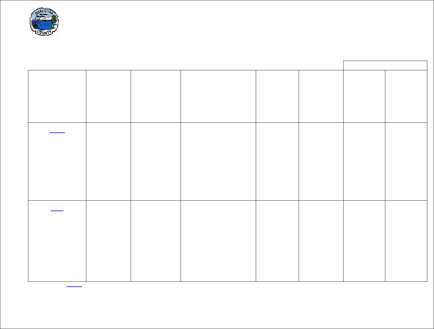
LAND DEVELOPMENT CODE Chapter 2
Zoning Regulations
____________________________________________________________________________________
2-46
Non Residential Uses
Zoning District
Minimum
Lot Size
Maximum
Density
Minimum Building
Setbacks
Front Side Rear
Minimum
Lot
Frontage
Maximum
Building
Height * +
Maximum
Lot
Coverage
Impervious
Surface
Coverage
(ISC)
Maximum
Floor Area
Ratio (FAR)
R-2
1 - Single-family
detached
2- -Single-family
attached (Townhouse,
minimum 2 units per
building)
3 - Duplex, triplex,
quadraplex
4 - Multi-family building
6 du/1 acre
1
16 du/1 acre 2
16 du/1 acre 3
16 du/1 acre 4
20’ 7.5’ 10’
20’ 7.5’ 10’
20’ 10’ 10’
20’ 10’ 10’
20’
20’
20’
20’
45’
45’
45’
45’
55%
55%
55%
55%
0.10
0.10
0.10
0.10
SR
1 - Single-family
detached
2 - Single-family
attached (Townhouse,
minimum 2 units per
building)
3 - Duplex, triplex,
quadraplex
4 - Multi-family building
6 du/1 acre
1
16 du/1 acre 2
16 du/1 acre 3
16 du/1 acre 4
20’ 7.5’ 10’
20’ 7.5’ 10’
20’ 10’ 10’
20’ 10’ 10’
20’
20’
20’
20’
45’
45’
45’
45’
60%
0.25
+ See Section 2.19.00 for additional building height restrictions
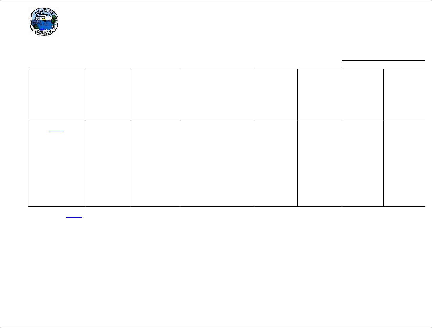
LAND DEVELOPMENT CODE Chapter 2
Zoning Regulations
____________________________________________________________________________________________________________________
2-47
Non Residential Uses
Zoning District
Minimum
Lot Size
Maximum
Density
Minimum Building
Setbacks
Front Side Rear
Minimum
Lot
Frontage
Maximum
Building
Height * +
Maximum
Lot
Coverage
Impervious
Surface
Coverage
(ISC)
Maximum
Floor Area
Ratio (FAR)
R-3
1 - Single-family
detached
2 - Single-family
attached (Townhouse,
Minimum 2 units per
building)
3- Duplex, Triplex,
quadraplex
4- Multi-family building
5- Subject to approval by
the Aviation Advisory
Committee
8 du/1 acre
1
16 du/1 acre 2
16 du/1 acre 3
25 du/1 acre 4
20’ 10’ 10’
20’ 10’ 10’
20’ 10’ 10’
20’ 10’ 10’
20’
20’
20’
20’
200’
5
200’ 5
200’ 5
200’ 5
55%
55%
0.10
55%
+ See Section 2.19.00
for additional building height restrictions
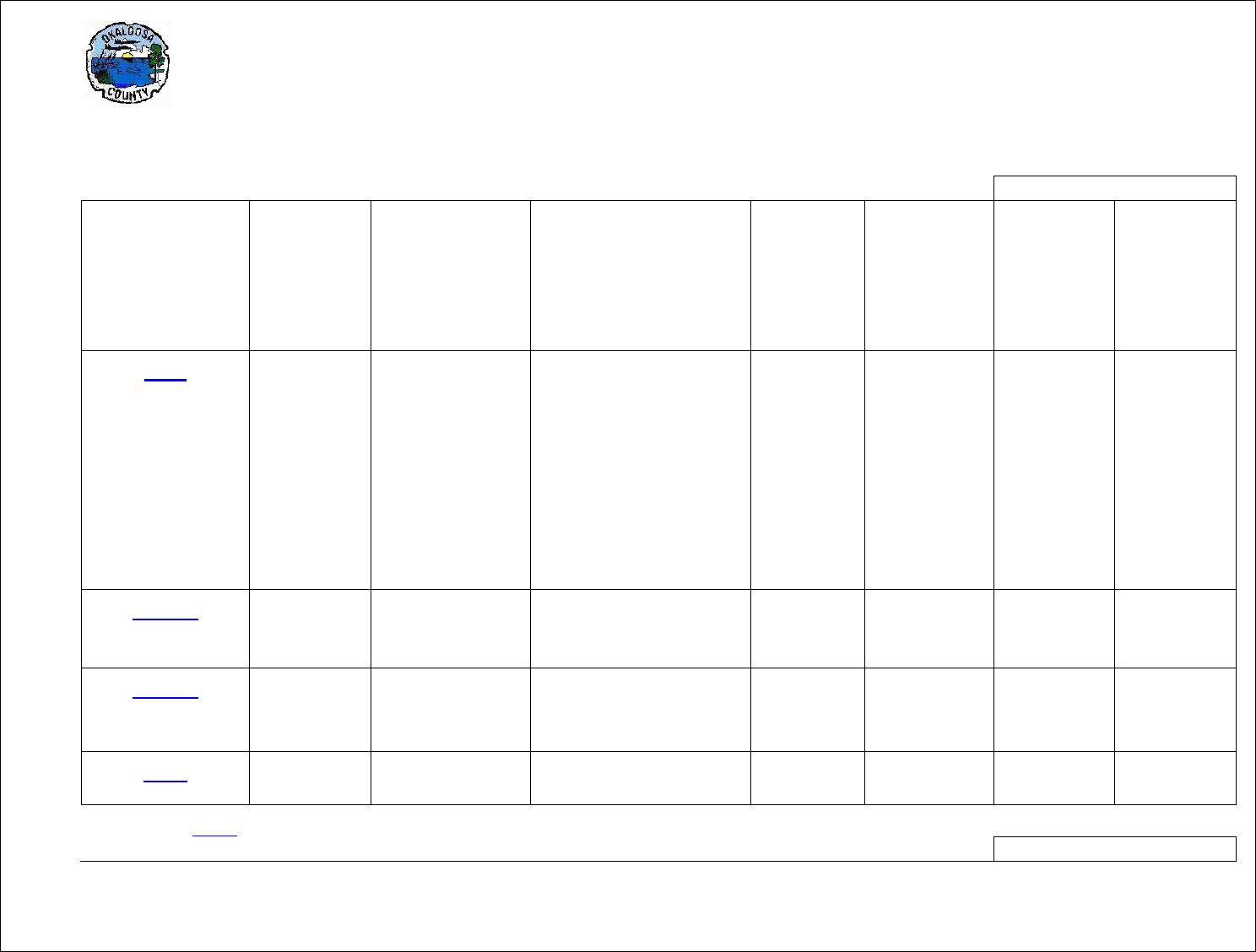
LAND DEVELOPMENT CODE Chapter 2
Zoning Regulations
____________________________________________________________________________________________________________________
2-48
Non Residential Uses
Zoning District
Minimum
Lot Size
Maximum
Density
Minimum Building
Setbacks
Front Side Rear
Minimum
Lot
Frontage
Maximum
Building
Height * +
Maximum
Lot
Coverage
Impervious
Surface
Coverage
(ISC)
Maximum
Floor Area
Ratio (FAR)
MU
Inside UDAB
Outside UDAB
1
- Subject to approval
by the Aviation Advisory
Committee
25 du/1 acre
4 du/1 acre
20’ 5’ 10’
20’ 10’ 10’
20’
20’
200’ 1
45’
75%
50%
0.75
0.10
MU-1
As specified in
Comprehensive Plan
Future Land Use
Element Policy 10.1, 5
65%
0.75
MU-2
As specified in
Comprehensive Plan
future Land Use
Element Policy 10.1, 6
65%
0.75
C-1
subject to the density
limitations of the R-3
10’ 0’ 10’
75%
0.75
+ See Section 2.19.00
for additional building height restrictions
Non Residential Uses
LAND DEVELOPMENT CODE Chapter 2
Zoning Regulations
____________________________________________________________________________________________________________________
2-49
Zoning District
Minimum
Lot Size
Maximum
Density
Minimum Building
Setbacks
Front Side Rear
Minimum
Lot
Frontage
Maximum
Building
Height * +
Maximum
Lot
Coverage
Impervious
Surface
Coverage
(ISC)
Maximum
Floor Area
Ratio (FAR)
C-2
subject to the
density limitations of
the R-3
10’ 0’ 10’
45’
75%
0.75
C-3
subject to the
density limitations of
the R-3
10’ 0’ 10’
75’
85%
0.75
AC-.5
½ acre
2 du/1 acre
20’ 10’ 10’
80’
20’
(for
Cul-de sac)
45’
AC-1
1 acre
1 du/1 acre
20’ 10’ 10’
80’
20’
(for
Cul-de sac)
45’
I-1
Inside UDAB
Outside UDAB
10 du/1 acre
4 du/1 acre
100’
100’
85%
85%
0.75
0.75
I-2
100’
85%
0.75
INST
Inside UDAB
Outside UDAB
10 du/1 acre
4 du/1 acre
75’
75’
65%
65%
0.75
0.75
REC
75’
85%
0.75
+ See Section 2.19.00 for additional building height restrictions

LAND DEVELOPMENT CODE Chapter 2
Zoning Regulations
____________________________________________________________________________________
2-50
2.18.00 RESIDENTIAL DESIGN ALTERNATIVES
2.18.01 Purpose: The purpose of this section is to provide innovative and flexible residential
development design alternatives for the purposes of: promoting the development of housing that the
average household can afford; preserving open space and environmental resources; promoting the
economy and efficiency of development design, and; making more efficient use of public and/or private
infrastructure.
2.18.02 Design Alternatives: Design alternatives authorized by this section are:
1. Cluster subdivisions;
2. Zero-lot-line development;
3. Angled Z-lots, and;
4. Zipper lots.
2.18.03 Cluster Subdivisions: The cluster subdivision is intended to permit a reduction in lot area and
bulk regulations, provided there is no increase in the overall density of the development, so that the
remaining land area may be devoted to open space, recreation, or preservation of environmental
resources. The following requirements shall apply to cluster subdivisions.
1. Cluster subdivisions are allowed only in R-1, R-2, R-3
and Mixed Use zoning
districts.
2. Permitted/conditional uses and bulk regulations shall be the same as for the R-1, R-2, and R-3
zoning districts, except that setbacks may be reduced to a minimum 20 feet front, 10 feet rear,
and 5 foot sides to accommodate smaller lots.
3. Allowable density shall not exceed the allowable densities for the R-1, R-2
,
and R-3 zoning districts.
4. The subdivision must be located on one contiguous parcel of land.
5. A minimum of 25% of the overall parcel must be set aside for open space, public or private
recreation, or preservation of environmental resources. Any such reservations made in this
manner shall be in perpetuity through dedications, conservation easement, homeowner’s
association, restrictive covenants or other similar means.
6. Lot sizes outside the dedicated area may be reduced in size to the extent necessary to re-capture
the allowable density for the entire property involved provided, however, lot sizes shall not be
smaller than 5,000 square feet.
7. In the event a cluster subdivision property abuts or is adjacent to a less dense residential
subdivision the lots shall be clustered to the interior of the property or otherwise away from the
less dense subdivision so that the area to be preserved acts as a buffer area between the two.
2.18.04 Zero-Lot-Line Development: The zero-lot-line development concept shifts the house to one side
of a building lot with the primary yard space to the other side. This provides for smaller lots with greater
usable yard on each lot. The following requirements shall apply to zero-lot-line developments.
1. Zero-lot-line developments are allowed only in R-1, R-2, R-3 and MU
zoning districts.

LAND DEVELOPMENT CODE Chapter 2
Zoning Regulations
____________________________________________________________________________________
2-51
2. Permitted/conditional uses shall be the same as for the R-1 zoning district.
3. Allowable residential density shall be up to 8 dwelling units per acre.
4. Minimum lot size shall be 5,500 square feet.
5. Yard setbacks shall be: Front – 20 feet
Sides – 0 feet, 10 fee
[no portion of a building may extend across a property line]
Rear – 10 feet
6. Minimum lot frontage: Square or rectangular – 50 feet
Irregular or cul-de-sac – 20 feet
7. Maximum building height: 45 feet
8. In the event a zero-lot-line development abuts or is adjacent to a less dense residential
subdivision the lots shall be arranged so that the side of the lot where the yard is located shall
abut the less dense subdivision; and a fence, wall, berm, or vegetated buffer shall be installed
between the zero-lot-line development and the less dense subdivision.
2.18.05 Z-Lots and Angled Z-Lots: Angled Z-lots provide for a portion of opposite sides of the lot to be
placed on the lot line. An angled Z-lot tilts the lot 30 – 40 degrees to alternate side and front entry garage.
Requirements for angled Z-lots shall be the same as for zero-lot-line developments.
2.18.06 Zipper Lots: For zipper lots the rear lot line jogs back to vary the depth of the rear yard and to
concentrate usable open space on the side of the lot. The following requirements shall apply to zipper
lots.
1. Zipper lots are allowed only in R-1, R-2, R-3 and MU
zoning districts.
2. Permitted/conditional uses shall be the same as for the R-1 and R-2
zoning districts.
3. Allowable residential density shall be up to 8 dwelling units per acre.
4. Minimum lot size shall be 5,500 square feet.
5. Yard setbacks shall be: Front - 20 feet
Sides - 7.5 feet
Rear - 0 feet
6. Minimum lot frontage: Square or rectangular - 50 feet
Irregular or cul-de-sac - 20 feet
7. Maximum building height: 35 feet

LAND DEVELOPMENT CODE Chapter 2
Zoning Regulations
____________________________________________________________________________________
2-52
2.19.00 BULK REGULATIONS FOOTNOTES
Footnotes defining requirements:
1. In all zoning districts, the setback requirements from the mean high-water line (MHWL) do not
apply to boat docks, piers, bulkheads (seawalls) or boathouses. For principal structures on tidal
waterfront lots, the setback from the mean high-water line (MHWL) is fifty (50) feet.
2. The setback from any natural non-tidal waters shall be twenty-five (25) feet from the ordinary
high-water line. A vegetative buffer shall be retained as required by Chapter 6
of this ordinance.
a. For all buildings one or two stories in height which are less than thirty-five (35) in
height, the minimum side and rear yards indicated on the Schedule of Dimensional
Requirements shall apply. Buildings one or two stories in height utilized for
residential or multi-family purposes on the same lot shall be a minimum of ten (10)
feet apart.
b. For all buildings three (3) stories in height or greater than thirty-five (35), except
single-family detached dwellings, the minimum side setback shall be fifteen (15) feet
on each side and the minimum rear setback shall be twenty (20) feet and further;
buildings located on the same lot shall be a minimum of fifteen (15) feet apart.
c. For all buildings four or more stories in height the minimum side setback shall be
twenty (20) feet and increased by two (2) feet on each side for each story exceeding
four (4) stories, with a minimum twenty-five (25) foot rear yard setback required. All
setbacks to be unobstructed for access with construction and landscaping of
setbacks to be reviewed and recommended by the Fire Chief of the District involved.
All buildings four (4) or more stories in height, the distance apart on the same lot shall
be increased by two (2) feet for each story starting with the fourth story; with a
maximum of fifty (50) feet between buildings being required.
3. In all commercially zoned (C-1, C-2, and C-3
) districts for all buildings two (2) stories or less in
height, no side or rear yards are required except where the property line is contiguous with a
residential use; then a buffer or screen, as required in Section 6.05.07 shall be installed. Two (2)
or more buildings located on the same lot shall be a minimum ten (10) feet apart for one (1) or
two (2) story buildings.
4. Density Bonus for Affordable Housing:
a. When the developer of a housing project with five (5) or more units agrees to build at
least one-quarter (1/4) of a project’s units for persons and families of low or moderate
income, the County will grant a density bonus of at least twenty-five (25) percent more
units than normally allowed by the existing zoning of the property.
b. Specifically, “density bonus” means a density increase of at least twenty-five (25) percent
over the otherwise allowable residential density under the applicable zoning district.
c. Persons and families of low and moderate income are defined as those whose incomes
are less than eighty (80) percent of the median income in the area, adjusted for family
size.

LAND DEVELOPMENT CODE Chapter 2
Zoning Regulations
____________________________________________________________________________________
2-53
d. Affordable Housing projects shall receive expedited review as a minor development,
requiring Technical Review Committee and Board of County Commissioners approval
only.
e. The affordability of the identified housing units shall be secured by a restrictive covenant,
or deed restriction recorded prior to the issuance of a certificate of occupancy.
6. Compatibility Analysis: Requests to exceed the seventy-five (75) foot maximum height shall be
subject to a Compatibility Analysis consisting of the following items: (1) Type of use in relation to
established and stable land uses; (2) Building location, dimensions, Floor Area Ratio building
height and orientation; (3) Parking and access; (4) Traffic impacts of noise, hours and lighting; (5)
Light and air as they affect visibility and shadows; (6) Setbacks, buffers, including fences, walls,
landscaping and open space treatment.

LAND DEVELOPMENT CODE Chapter 2
Zoning Regulations
____________________________________________________________________________________
2-54
2.20.00 SPECIAL USES
2.20.01 Alcoholic Beverage Establishments:
1. General Provisions: It shall be unlawful to sell, or offer to keep for sale, alcoholic beverages
containing more than one percent (1%) of alcohol by weight in any place or establishment,
including a private club or bottle club, for which the appropriate Florida Department of Business
and Professional Regulation/Division of Alcoholic Beverages and Tobacco license has not been
issued.
2. Distance from churches, schools, cemeteries, residential zoning districts, and residential uses:
Except those vendors licensed in accordance with Section 561.422
. and non-profit civic
organizations permitted pursuant to Section 561.422,. and other exemptions provided herein, no
vendor of alcoholic beverages as described in (1.) above establishment licensed pursuant to (1.)
above for consumption on premises shall be located within one thousand five hundred feet
(1,500’) of a church, school, cemetery, residential zoning district or residential use. The distance
shall be determined by measuring a radius from the closest improved part of the property
(excluding stormwater treatment facilities and landscape buffers) supporting the alcoholic
beverage establishment to the nearest parcel of land on which occurs a school, church,
cemetery, residential zone, or residential use. If any portion of a parcel of land in use as a
residence lies within such radius, or if any portion of a parcel of land containing a church, school
or cemetery lies within the radius, or if a residential zone lies within the radius, then the
establishment shall be deemed to be within such distance. This methodology shall apply to all
distance measurements undertaken pursuant to
2.20.01.
3. Notwithstanding the requirements of 2, above, the following uses that serve or sell alcoholic
beverages for consumption on premises may be located closer than 1,500 feet of a church,
school, or cemetery, residential zoning district, or residential use:
a. Uses listed in sections 561.20(2) and (7), Fla. Stat
.;
b. Restaurants which do not qualify for the special State license (4COP-SRX) allowing on
premise consumption of beer, wine, and liquor may also be allowed provided the
following criteria are met:
i. except as provided in (5.), below, there is no outdoor serving of alcoholic
beverages within 300 feet of a residential use or zone;
ii. at no time will the kitchen be closed while the establishment is serving beverages
or other foods to customers, including private parties;
iii. no less than 51% of gross receipts are from the sale of non-alcoholic food and
beverages;
c. Private clubs that are included among the uses allowed in a master-planned community
or mixed use development at the time of approval when such approval was obtained
through a public hearing;
d. Yacht clubs; and
e. Uses authorized pursuant to Section 561.422
, Fla. Stat.;

LAND DEVELOPMENT CODE Chapter 2
Zoning Regulations
____________________________________________________________________________________
2-55
4. The provisions of Section 2.20.01 (3.) notwithstanding, the on-premise consumption of alcoholic
beverages at establishments licensed pursuant to A, above, shall be prohibited within 100’ of any
residential use or residential zoning district unless all of the following are met:
a. the use is a restaurant at which no less than 51% of gross receipts are from the sale of
non-alcoholic food and beverages,
b. alcohol is limited to beer and wine only,
c. there is no outside serving of alcoholic beverages, and
d. there is no service of alcohol after 10:00 PM Sunday through Thursday, or after 11:00 PM
on Friday and Saturday.
5. Notwithstanding (3.) and (4.), above, in order to facilitate in-fill development, mixed use
development, and re-development, alcoholic beverage establishments licensed pursuant to A,
above, may be allowed less than 100 feet from residential uses or residential zoning districts
when the only residential uses or zones within 100 feet from the proposed alcoholic beverage
establishment are authorized through the same development order, Master Plan Development
Order, Development Agreement, Development of Regional Impact Development Order, or
Planned Unit Development ordinance as the proposed alcoholic beverage establishment.
6. Outdoor serving of alcoholic beverages within 300 feet (measured using the same method as
provided in Section 2.20.01 (2.)
of a residential zone or use is permitted only through the granting
of a Special Exception as provided by Section 1.11.03 and Section 11.02.09 of this Code and
shall cease between the hours of 10:00 PM and 7:00 AM Central Time unless more restrictive
hours are established by the Board of Adjustment as a condition of approval of the special
exception.
7. All new applications for alcoholic beverage licenses at locations that have not previously been
occupied by an alcoholic beverage establishment within 300’ of a residential use or zone shall
include a compatibility analysis that illustrates consistency with applicable compatibility criteria
provided in the Comprehensive Plan, and which shall specifically include proposed hours of
operation.
8. The Growth Management Director or his/her designee, shall be responsible for verifying to the
Florida Division of Alcoholic Beverages and Tobacco or such other regulatory agencies,
compliance with the above requirements for a restaurant seeking the issuance of an alcoholic
beverage license. The Growth Management Director, or his/her designee, is authorized to
require that applicants provide all documentation (such as site plans, floor plans, lease
agreements, etc) necessary to verify compliance with the above requirements.
9. The above requirements are solely intended to determine whether a proposed food and beverage
establishment is consistent with zoning and other Okaloosa County codes. This part is not
intended, nor shall it be construed, to preempt, overrule, waive, or otherwise exempt any
proposed establishment from any other applicable federal, state, or local law or regulation. In the
event the provisions contained herein conflict with any other applicable federal, state, or local law
or regulation, the more stringent shall apply.
10. Uses in existence as of the effective date of this section shall not be rendered non-conforming by
these provisions, nor shall the provisions of this section preclude the reconstruction of an

LAND DEVELOPMENT CODE Chapter 2
Zoning Regulations
____________________________________________________________________________________
2-56
alcoholic beverage establishment following a disaster (fire, flood, etc), provided all other
applicable building, zoning, and other codes are met.
2.20.02 Animal Hospitals, Veterinary Clinics, Commercial Kennels and Businesses that Board
Animals:
1. Minimum setbacks: Any animal hospital, veterinary clinic, commercial kennel or business that
boards animals, which includes outside cages and runs, shall be located no closer than one
hundred (100) feet to a residence or residential zoning district boundary line, measured from the
outside of the building, cages or runs to the residential property or residential zoning district line,
and such line being measured from the nearest residential property or residential zoning district to
the closest building, cage or run.
2. Buffer Yard Required: The animal hospital, veterinary clinic, commercial kennel or business that
boards animals which includes outside cages or runs shall comply with buffer yard regulations
established in Chapter 6 of this Code. In addition to the buffer requirements in Chapter 6
, the
outside cages, runs or exercise yards shall be totally enclosed by a solid fence at least six (6) feet
in height.
2.20.03 Cemeteries:
1. "Cemetery" means a place dedicated to and used or intended to be used for the permanent
interment of human remains or cremated remains. A cemetery may contain land or earth
interment; mausoleum, vault, or crypt interment; a columbarium, ossuary, scattering garden, or
other structure or place used or intended to be used for the interment or disposition of cremated
remains; or any combination of one or more of such structures or places.
2. All cemeteries must comply with applicable law and rules including Chapter 497, Fla. Stat
. and
Rule 69-K, Fla. Admin. Code.
3. Cemeteries are allowed in AA, C-3, and INST
zoning districts. A family cemetery less than two
acres in size which does not sell or offer out burial spaces, rights, or merchandise may also be
allowed in the RR zoning district when:
a. a letter of no objection is obtained from all adjacent property owners for parcels one acre
or less;
b. the cemetery site is located no closer than 25 feet from any property line, and;
c. there is adequate ingress and egress to allow family members to visit the burial spaces.
2.20.04 Churches and Other Religious Institutions:
1. Regulations: All churches and other religious institutions shall comply with building setback, area
and height regulations set forth within each zoning district. Where a church or other religious
institution is proposed adjacent to a residential land use or vacant property within or contiguous to
a residential zoning district, there shall be a buffer as established in Chapter 6
between the
church and the surrounding property line.

LAND DEVELOPMENT CODE Chapter 2
Zoning Regulations
____________________________________________________________________________________
2-57
2. Off-street parking: Parking shall comply with the applicable regulation in Chapter 6. On-street
parking within five hundred (500) feet of the building, except in residential districts, may be used
toward fulfilling this requirement.
3. Lot coverage in residential districts: The maximum combined area of all principal and accessory
buildings shall not exceed thirty (30) percent of the site.
2.20.05 Public Schools and other Public Institutions
1. Public Schools and other public institutions are permitted in all zoning districts.
2. Minimum Site Area: For new public schools and other public institutions, the minimum lot size
shall comply with state standards.
3. Setbacks: All new public schools and public institutions shall have a front setback
4. of forty (40) feet, and side and rear setbacks of twenty-five (25) feet.
5. Reference Section 6.04
for parking requirements.
6. Reference Section 6.05
for landscaping and buffering requirements.
2.20.06 Private Airports; Residential Airparks
A. Private Airport
1. "Airport" means an area of land or water used for, or intended to be used for, landing and takeoff
of aircraft, including appurtenant areas, buildings, facilities, or rights-of-way necessary to facilitate
such use or intended use. "Private airport" means an airport, publicly or privately owned, which is
not open
or available for use by the public, but may be made available to others by invitation of
the owner or manager. Private airports may be allowed by special exception in AA, INST, and I-1
zoning districts subject to requirements specified herein.
2. All private airports must comply with the provisions of Chapter 330, Fla. Stat
. as well as any other
federal or state permits, licenses or authorizations. Any such authorizations must be obtained
prior to or as a condition of the granting of a special exception.
3. Uses and activities allowed within a private airport include the following:
a. Runway(s), taxiways, parking ramps, and hangars for the use of the licensee and
licensee invitees for the parking and storing of aircraft.
b. Residential dwellings provided that it does not constitute a subdivision as defined in
Chapter 177, Fla. Stat
., a copy of which is attached hereto. Noncommercial fuel facilities
for the not for profit use of the licensee and invitees, provided the facility is properly
permitted to meet health and safety standards.
c. Permitted and accessory uses as allowed by the applicable zoning district regulations.

LAND DEVELOPMENT CODE Chapter 2
Zoning Regulations
____________________________________________________________________________________
2-58
d. Activities essential to and commensurate with the operation of an airport, including but
not limited to flight instruction, aircraft storage, aircraft maintenance, aircraft fueling and
other activities appropriate at a private airport.
B. Residential Airparks
1. A Residential Airpark is a residential subdivision containing a private airport for the use of the
owner(s) and invitees. Residential airparks may be allowed by special exception in the AA
and
RR zoning districts subject to requirements specified herein.
a. All requirements for a private airport shall apply.
b. Any residential airpark shall be compatible with the established character of the
surrounding neighborhood and be of a scale and intensity that shall not result in an
adverse impact on residential uses in the surrounding neighborhood.
c. A legal entity shall be created to be responsible for ownership and maintenance of any
common space. The legal entity may be a property owner’s association, homeowner’s
association or other appropriate entity approved by the County. A document shall be
prepared and recorded which contains either restrictions or protective covenants. The
document shall be included with the recorded plat for the subdivision.
d. The following uses may be allowed within the airpark to be determined by the special
exception.
i. Single and multi-family dwelling units provided they do not exceed the Future
Land Use category density, and aircraft hangars on individual platted lots.
ii. Private runway(s), taxiway(s), and parking ramp(s) on designated common areas
or area under unified control of the subdivision.
iii. Noncommercial fuel facilities for the not for profit use of owners of platted lots
and invitees.
2.20.07 Dog Friendly Dining Establishments:
1. Pursuant to section 509.233(1), Fla. Stat
. there is hereby created a local exemption procedure to
certain provisions of the United States Food and Drug Administration Food Code, as amended
from time to time, and as adopted by the State of Florida Division of Hotels and Restaurants of
the Department of Business and Professional Regulation, in order to allow patrons’ dogs within
certain designated outdoor portions of public food service establishments, which exemption
procedure may be known as the Okaloosa County Dog Friendly Dining Program.
2. Definitions. As used in this section,
a. “Division” means the Division of Hotels and Restaurants of the State of Florida
Department of Business and Professional Regulation.
b. “Dog” means an animal of the subspecies Canis lupus familiaris
.

LAND DEVELOPMENT CODE Chapter 2
Zoning Regulations
____________________________________________________________________________________
2-59
c. “Outdoor area” means an area adjacent to a public food service establishment that is
predominantly or totally free of any physical barrier on all sides and above.
d. “Patron” has the meaning given to “guest” by section 509.013, Fla. Stat..
e. “Public food service establishment” has the meaning given it by section 509.013, Fla. Stat
f. “Planning Official” is the Director of the Department of Growth Management.
3. Permit Required; Submittals.
Applications for a permit under this part shall be made to the Planning Official, on a form provided
for such purpose by the Planning Official, and shall include, along with any other such information
deemed reasonably necessary by the Planning Official to implement and enforce the provisions
of this part, the following:
a. The name, mailing address, and telephone contact information of the permit applicant
and the subject food service establishment.
b. A diagram and description of the outdoor area to be designated as available to patrons’
dogs, including dimensions of the designated area; a depiction of the number and
placement of tables, chairs, and restaurant equipment, if any; the entryways and exits to
the designated outdoor area; the boundaries of the designated area and of any other
areas of outdoor dining not available for patrons’ dogs; any fences or other barriers;
surrounding property lines and public rights-of-way, including sidewalks and common
pathways; and such other information reasonably required by the Planning Official. Any
dog-friendly dining area established pursuant to this part located on a property adjacent
to any public or private beach must be secured such that dogs cannot access the beach
from the premises. The diagram and description provided pursuant to this part shall
clearly illustrate and describe how dogs shall be prevented from accessing the beach.
The diagram or plan shall be accurate and to scale but need not be prepared by a
licensed design professional.
c. A description of the days of the week and hours of operation that patron’ dogs will be
permitted in the designated outdoor area.
d. All application materials shall contain the appropriate division issued license number for
the subject public food service establishment.
4. General Regulations; Cooperation; Enforcement; Penalty.
In order to protect the health, safety, and general welfare of the public, and pursuant to
section
509.233, Fla. Stat. all permits issued pursuant to this part are subject to the following
requirements:
a. All public food service establishment employees shall wash their hands promptly after
touching, petting, or otherwise handling any dog. Employees shall be prohibited from
touching, petting, or otherwise handling any dog while serving food or beverages or
handling tableware or before entering other parts of the public food service
establishment.

LAND DEVELOPMENT CODE Chapter 2
Zoning Regulations
____________________________________________________________________________________
2-60
b. Patrons in a designated outdoor area shall be advised that they should wash their hands
before eating. Waterless hand sanitizer shall be provided at all tables in the designated
outdoor area.
c. Employees and patrons shall be instructed that they shall not allow dogs to come into
contact with serving dishes, utensils, tableware, linens, paper products, or any other
items involved in food service operations.
d. Patrons shall keep their dogs on a leash at all times and shall keep their dogs under
reasonable control.
e. Dogs shall not be allowed on chairs, tables, or other furnishings.
f. All table and chair surfaces shall be cleaned and sanitized with an approved product
between seating of patrons. Spilled food and drink shall be removed from the floor or
ground between seating of patrons.
g. Accidents involving dog waste shall be cleaned immediately and the area sanitized with
an approved product. A kit with the appropriate materials for this purpose shall be kept
near the designated outdoor area.
h. At least one sign reminding employees of the applicable rules, including those contained
in this part, and those additional rules and regulations, if any, included as further
conditions of the permit by the Planning Official, shall be posted in a conspicuous location
frequented by employees within the public food service establishment. The mandatory
sign shall be not less than eight and one-half inches in width and eleven inches in height
(8 ½ x 11) and printed in easily legible typeface of not less than twenty (20) point font
size.
i. At least one sign reminding patrons of the applicable rules, including those contained in
this part, and those additional rules and regulations, if any, included as further conditions
of the permit by the Planning Official, shall be posted in a conspicuous location within the
designated outdoor portion of the public food service establishment. The mandatory sign
shall be not less than eight and one-half inches in width and eleven inches in height (8 ½
x 11) and printed in easily legible typeface of not less than twenty (20) point font size.
j. At all times while the designated outdoor portion of the public food service establishment
is available to patrons and their dogs, at least one sign shall be posted in a conspicuous
and public location near the entrance to the designated outdoor portion of the public food
service establishment, the purpose of which shall be to place patrons on notice that the
designated outdoor portion of the public food service establishment is currently available
to patrons accompanied by their dog or dogs. The mandatory sign shall be not less than
eight and one-half inches in width and eleven inches in height (8 ½ x 11) and printed in
easily legible typeface of not less than twenty (20) point font size.
k. Dogs shall not be permitted to travel through indoor or undesignated outdoor portions of
the public food service establishment, and ingress and egress to the designated outdoor
portions of the public food service establishment shall not require entrance into or
passage through any indoor or undesignated outdoor portion of the public food service
establishment.

LAND DEVELOPMENT CODE Chapter 2
Zoning Regulations
____________________________________________________________________________________
2-61
l. A permit issued pursuant to this part shall not be transferred to a subsequent owner upon
the sale or transfer of a public food service establishment, but shall expire automatically
upon such sale or transfer. The subsequent owner shall be required to reapply for a
permit pursuant to this part if such owner wishes to continue to accommodate patrons’
dogs.
m. In accordance with section 509.233(6), Fla. Stat
. the Planning Official shall accept and
document complaints related to the Dog Friendly Dining Program within the County, and
shall timely report to the division all such complaints and the County’s enforcement
response to such complaint. The Planning Official shall also timely provide the division
with a copy of all approved applications and permits issued pursuant to this part.
n. Any public food service establishment that fails to comply with the requirements of this
part shall be guilty of violating this part of the Land Development Code and shall be
subject to any and all enforcement proceedings consistent with the applicable provisions
of the Code and general law.
2.20.08 Tall Structures:
In zoning districts where tall structures and/or temporary or permanent obstacles are permitted, structures
and/or temporary or permanent obstacles in excess of one hundred (100) feet will be required to obtain
determination of “No Hazard to Aviation” from the Federal Aviation Administration, be submitted to the
Aviation Advisory Committee and the Planning Commission for recommendation, and the applicant must
obtain final approval from the Board of County Commissioners.
2.20.081 Towers and Telecommunications Facilities:
Purpose: The general purpose of this section is to regulate the placement, construction and
modification of towers and telecommunication facilities in order to protect the health, safety and
welfare of the public. The specific purposes of this section are:
1. To regulate the location of towers and telecommunications facilities in the County;
2. To protect residential areas and land uses from potential adverse impact of tower and
telecommunications facilities;
3. To minimize adverse visual impact of towers and telecommunications facilities through
careful design, siting, landscaping, and camouflaging techniques;
4. To promote and require shared use and co-location of towers and antenna support structures
as opposed to the construction of additional single-use towers;
5. To avoid potential damage to property caused by towers and telecommunications facilities by
ensuring that such structures are sound and carefully designed, constructed, modified,
maintained and removed when no longer used or determined to be structurally unsound;
6. To ensure that towers and telecommunications facilities are compatible with surrounding land
uses, and their location and height do not interfere with or degrade the U.S. military mission
or activities, and

LAND DEVELOPMENT CODE Chapter 2
Zoning Regulations
____________________________________________________________________________________
2-62
7. To facilitate the provision of wireless telecommunications services to the residents and
businesses of the County in an orderly fashion.
Definitions: The following words, terms and phrases, when used in this section shall have the
meanings ascribed to them in this section, except where the context clearly indicates a different
meaning:
1. Antenna Array: means one or more rods, panels, discs or similar devices used for the
transmission or reception of radio frequency signals, which may include omni-directional
antenna (rod), directional antenna (panel), or parabolic antenna (disc), but does not include
the support structure.
2. Applicant: means any person that applies for a tower development permit.
3. Application: means the process by which an applicant submits a request to develop,
construct, build, modify or erect a tower. Application includes all written documentation,
verbal statements and representations, in whatever form or forum, made by an Applicant to
the County concerning a request.
4. CMRS: means Commercial Mobile Radio Services, as defined in §704 of the
Telecommunications Act of 1996, which includes cellular, personal communications,
specialized mobile radio, enhanced specialized mobile radio, and similar services that
currently exist or that may in the future be developed.
5. Co-location or Co-locate: means the use of a tower by two (2) or more CMRS license
holders or by one CMRS license holder for more than one type of communications
technology.
6. Engineer: means any engineer licensed by the State of Florida. Radio frequency engineers
do not have to be licensed by the State, however their qualifications must include specific
experience in the field and employment or retention by the telecommunications provider in a
professional, technical capacity.
7. Owner: means any person with fee title, or with written permission from a person with fee
title, to any plot of land within the County who desires to develop, construct, build, operate,
modify or erect a tower upon such land.
8. Person: is any natural person, firm, partnership, association, corporation, company or other
legal entity, private or public, whether for profit or not-for-profit.
9. Telecommunications Facility: means any cables, wires, lines, wave guides, antennas and
any other equipment or facilities associated with the transmission or reception of
communication which a person seeks to locate or has installed upon or near a tower or
antenna support structure. However, the term “telecommunications facilities” shall not
include:
a. Any satellite earth station antenna two (2) meters in diameter or less which is located
in an area zoned for industrial or commercial uses; or
b. Any satellite earth station antenna one (1) meter or less in diameter, regardless of
zoning category.

LAND DEVELOPMENT CODE Chapter 2
Zoning Regulations
____________________________________________________________________________________
2-63
10. Tower: means a self-supporting lattice, guyed or monopole structure constructed from grade
which supports telecommunications facilities.
Applicability:
1. Towers and telecommunications facilities for which a permit has been issued prior to the
effective date of this section shall not be required to meet the requirements of this section,
except as provided herein.
2. This section shall not govern the installation of any amateur radio facility that is owned and
operated by a federally licensed amateur radio station operator or is used exclusively for
receive-only antennas.
3. In the event of any conflict or inconsistency between this Section and Subsection
365.172(11), Fla. Stat
the applicable statutory provision shall control and govern.
Applications: Applications shall comply with the following when requesting to construct or erect a
tower or place or locate a telecommunications facility or alteration or extension of an existing tower or
telecommunications facility thereupon, an owner must submit and obtain approval of an application.
Applications shall include:
1. The name, address and telephone number of the owner and lessee of the parcel of land upon
which the tower is proposed to be situated. If the applicant is not the actual owner of the
parcel of land upon which the tower is proposed to be situated, the written consent of the
actual owner shall be included with the application.
2. The legal description, parcel identification number and address of the parcel of land upon
which the tower is proposed to be situated.
3. The names, addresses and telephone numbers of all owners of other towers or usable
antenna support structures within a one half (1/2) mile radius of the proposed tower site.
4. Written documentation that the applicant made diligent, but unsuccessful efforts for a
minimum of thirty (30) days prior to submission of the application to install or co-locate the
applicant’s telecommunications facility on towers or usable antenna support structures
located within a one-half (1/2) mile radius of the proposed tower site or written, technical
evidence from a registered professional engineer that the proposed tower or
telecommunications facility cannot be installed or co-located on another tower or usable
antenna support tower site, and must be located at the proposed site in order to meet
coverage requirements of the applicant’s wireless communication system.
5. Written, technical evidence from a registered professional engineer that the proposed
structure meets the standards set forth in this article.
6. Written, technical evidence from a registered professional engineer that the proposed site of
the tower and telecommunications facility does not pose a risk of explosion, fire or other
danger due to its proximity to volatile, flammable, explosive or hazardous materials.
7. Written evidence that the tower and telecommunication facility are in compliance with Federal
Aviation Administration regulations. Where an antenna array will not exceed the highest

LAND DEVELOPMENT CODE Chapter 2
Zoning Regulations
____________________________________________________________________________________
2-64
point of an existing structure upon which the array is to be mounted, such evidence shall not
be required.
8. Written, technical evidence from a registered professional engineer that construction and
placement of the tower and telecommunications facility will not interfere with public safety
communications and the usual and customary transmission or reception of radio and
television service enjoyed by adjacent residential and non-residential properties.
9. A certification from a registered professional engineer documenting the co-location capability
of the applicant’s proposed tower.
10. A map showing the location of the proposed tower and the applicant’s existing network and
proposed construction and tower location plans in Okaloosa County for the next twelve 12
months.
Height and Co-location: Towers will only be allowed in those districts where they are permitted (AA,
C-2, C-3, I-1, INST
), and shall comply with the following;
1. Except as provided in this code, a tower shall be permitted to a height of up to one hundred
(100) feet.
2. Towers which have co-location of two (2) or more licensed carriers shall be permitted to a
height of up to one hundred eighty (180) feet in the C-2 and C-3 zoning districts meeting the
setback requirement in Paragraph E below, towers in excess of one hundred eighty (180) feet
and up to a maximum height of three hundred thirty (330) feet shall be permitted in the AA
and I-1 zoning districts, provided they have co-location ability and present commitment letters
from a minimum of three (3) licensed carriers at the time of application for review and
approval provided they are situated on a site a minimum of ten thousand (10,000) sq. ft. with
setbacks not less than five hundred (500) feet from the nearest existing residence unless
waived by the residential property owner. In that case, the minimum setback shall be one
hundred (100) percent of the tower height.
3. Antenna arrays shall not rise more than twenty (20) feet above the height of the tower or
antenna support structure.
4. New tower construction shall be required to provide co-location for a minimum of three (3)
licensed carriers. A tower shall be deemed to have co-location ability if its design is certified
by the registered professional engineer as being appropriate for co-location and the applicant
certifies that it is prepared to offer adequate space on the tower to others on commercially fair
and reasonable terms. An applicant’s requirement to provide adequate space on its tower for
co-location may be subject to the following factors (a) structural engineering capabilities,
taking into account planned future use by the applicant and municipal emergency services,
(b) radio frequency inter-modulation acceptance, (c) the acknowledgement of other CMRS
licensees wishing to co-locate on applicant’s tower to permit applicant to co-locate on a
reciprocal basis.
Setbacks:
1. All towers shall be designed, sited, and erected so that the tower will be set back a minimum
of 100 percent of the height of the proposed tower from the property line of any property
zoned for residential use or used for residential purposes, OR; the proposed tower will be

LAND DEVELOPMENT CODE Chapter 2
Zoning Regulations
____________________________________________________________________________________
2-65
designed, sited and erected within a specified “fall radius” which is totally within the
boundaries of the property where the tower is located, such fall radius to be certified and
sealed by a registered structural engineer.
2. Antenna arrays for antenna support structures are exempt from the setback standards of this
section and from the setbacks for the zone in which they are located. However, such
antenna arrays may extend no more than five (5) feet horizontally beyond the vertical plane
of the outer edge of the antenna support structure.
Separation: Proposed towers shall be separated from all other existing towers by a minimum of
seven hundred and fifty (750) feet, except where a tower field or antenna farm has been established
and the proposed tower can be safely located within the boundaries, the separation requirements
may be reduced, if approved by the County.
Illumination: Towers shall be lighted as required by the Federal Aviation Administration (FAA).
Further, unless prohibited by the FAA, towers for which illumination is not otherwise required by the
FAA shall have a beacon light placed at the top of the tower. To the extent allowed by the FAA, all
lighting and beacons upon a tower which, at the time of commencement of construction, shall be
erected with shields mounted underneath the lights or beacons in such a manner so as to obstruct
the view of lights or beacons from the ground.
Structural Requirements: Towers must be constructed in accordance with Electronic Industries
Association/Telecommunication Industries Association (EIA/TIA) 222 Revision F Standard entitled
“Structural Standards for Steel Antenna Towers and Antenna Supporting Structures”
(or equivalent),
as it may be updated or amended. All towers must be constructed of approved corrosion and
resistant noncombustible material. All towers must be permanently and effectively grounded. All
towers must be located and equipped with step bolts and ladders so as to provide ready access for
inspection purposes.
Maintenance:
1. Owners shall at all times employ ordinary and reasonable care and shall install, maintain and
use nothing less than commonly accepted methods and devices for preventing failures and
accidents which are likely to cause damage, injuries, or nuisances to the public.
2. Owners shall install and maintain towers and telecommunications facilities in substantial
compliance with the requirements of the National Electric and Safety Code and all FCC, state
and local regulations.
3. All towers, telecommunications facilities and antenna support structures shall at all times be
kept and maintained in good condition, order and repair so that the same shall not menace or
endanger the life property of any person.
4. In the event the use of a tower is discontinued by the owner, or if the owner ceases to
operate the tower, the owner shall provide written notice to the County of its intent to
discontinue use or cease operations, and the date when the use shall be discontinued.
Aesthetic Considerations:
1. All towers not requiring FAA painting or marking, shall have an exterior finish which enhances
compatibility with adjacent uses.

LAND DEVELOPMENT CODE Chapter 2
Zoning Regulations
____________________________________________________________________________________
2-66
2. Antenna arrays attached to antenna support structures which are significantly viewable to
adjacent residences shall be designed so as to blend in with existing structures to the extent
feasible, including placement in a location which is consistent with proper functioning of the
telecommunications facility, and the use of compatible or neutral colors.
3. Antenna arrays attached to antenna support structures which are significantly visible to
adjacent residences, which have aesthetic impacts that are not able to be reasonably
mitigated by placement or color solutions, can be required to be screened in a reasonable
and achievable manner, provided that such screening does not intentionally increase the
costs of constructing, erecting, and installing the antenna arrays.
4. All new tower bases, guy anchors, outdoor equipment, accessory buildings and accessory
structures erected for use in connection with towers and telecommunication facilities shall be
required to meet the minimum setback requirements established for the district in which they
are located, and be visually screened to a height of at least eight (8) feet by trees, large
shrubs, solid walls and/or fences, or as required by Section 6.05.074
.
Removal of Abandoned Facilities: A tower and/or telecommunication facility that is not operated
for a continuous period of twelve (12) months shall be considered abandoned, and the owner thereof
shall remove the same within ninety (90) days of abandonment or discontinuation of use. If such
tower or telecommunication facility is not removed within said ninety (90) days, the County may
remove such tower or telecommunications facility at the owner’s expense. If there are two or more
users of a single telecommunications facility, then this provision shall not become effective until all
users cease using the tower or telecommunications facility.
Inspections: The County and its agents shall have the authority to enter onto the property upon
which a tower is located, between the inspections and certifications required above, to inspect the
tower for purposes of determining whether it complies with all applicable laws and regulations. The
County reserves the right to conduct such inspections at any time, upon reasonable notice to the
owner. All expenses relating to such inspections by the County shall be upon the owner.
Nonconforming towers and telecommunication facilities: Towers and telecommunications
facilities in existence as of the effective date of this section that do not comply with the requirements
of this section are subject to the following:
1. Nonconforming towers and telecommunication facilities may continue in use for the purposes
now used, but may not be expanded without complying with this ordinance, except as
provided in this section
2. Nonconforming towers and telecommunications facilities may add additional antennas
belonging to the same carrier or other carriers, subject to administrative review otherwise
applicable to the addition and erection of antenna arrays
3. Nonconforming towers and telecommunication facilities which are hereafter damaged or
destroyed due to any reason or cause may be repaired or restored to their former use,
location and physical dimension subject to obtaining a building permit therefore ,but without
otherwise complying with this section.
4. The owner of any nonconforming tower and telecommunications facility may replace, repair,
rebuild and/or expand such tower and telecommunication facility in order to improve the
structural integrity of the facility, to allow the facility to accommodate co-location, or to

LAND DEVELOPMENT CODE Chapter 2
Zoning Regulations
____________________________________________________________________________________
2-67
upgrade the facility to current engineering, technological or communications standards,
without having to conform to the provisions of this section, so long as the facilities are not
increased in height and setbacks are not decreased.
2.20.082 Residential: The height limitations contained in the Schedule of Dimensional Requirements do
not apply to spires, belfries, cupolas, non commercial radio/television antennas, water tanks, ventilators,
chimneys, or other appurtenances usually required to be placed above the roof level and not intended for
human occupancy.
2.20.083 Exemption:
1. Amateur Radio antennas shall conform to the Federal Communication Commission
regulations and are exempted from requirements of this code regarding placement, screening,
and height pursuant to
Section 125.561, Fla. Stat.
2. Towers erected by government agencies for the purpose of official communication and emergency
response such as law enforcement, emergency medical service, evacuation, or national security are
essential public infrastructure and are allowed in any zoning district. Towers constructed pursuant to this
exemption shall be approved through the issuance of a building permit and development permit and shall
not be required to receive a development order or approval by the Planning Commission or Board of
County Commissioners.
A. At the time of application for a building permit, the following documentation shall accompany the
building permit application submitted to the Growth Management Department which shall be
reviewed by the Planning Division concurrent with the review of the building permit application
conducted by the Inspections Division:
1. The name, address and telephone number of the owner and lessee of the parcel of land upon
which the tower is proposed to be situated. If the applicant is not the actual owner of the parcel
of land upon which the tower is proposed to be situated, the written consent of the actual owner
shall be included with the application.
2. The legal description, parcel identification number and address of the parcel of land upon which
the tower is proposed to be situated.
3. Written, technical evidence from a licensed professional engineer that the proposed site of the
tower and telecommunications facility does not pose a risk of explosion, fire or other danger due
to its proximity to volatile, flammable, explosive or hazardous materials.
4. Written evidence that the tower and telecommunication facility will be constructed in compliance
with Federal Aviation Administration regulations. Towers 100 feet or more in height shall be
required to obtain a determination of "No Hazard to Air Navigation" from the Federal Aviation
Administration and shall also be submitted to the Aviation Advisory Committee for review and
comment prior to the submittal of permit applications to the Growth Management Department.
Where an antenna array will not exceed the highest point of an existing structure upon which the
array is to be mounted, such evidence shall not be required.
5. Written, technical evidence from a licensed professional engineer that construction and
placement of the tower and telecommunications facility will not interfere with radio, television, or
commercial wireless communication service enjoyed by adjacent residential and non-
r
esidential
properties.

LAND DEVELOPMENT CODE Chapter 2
Zoning Regulations
____________________________________________________________________________________
2-68
6. A study performed by a licensed professional engineer specific to the proposed location
demonstrating that the proposed height of the tower is the minimum necessary to serve the
intended public services. Sections 3.09.03 and 3.09.04 of the Land Development Code
notwithstanding, the height of the emergency response tower may exceed the height identified in
the 2006 Air Installation Compatible Use Zone Study for Eglin Air Force and the Eglin Joint Land
Use Study Final Report dated June 2009 if the FAA issues a determination that the tower does
not constitute a hazard to air navigation. In no case shall the height of a proposed tower or
antenna array exceed 75 feet on Okaloosa Island.
B. The Growth Management Department shall issue the requested permits upon determination that
the application is in compliance with the Florida Building Code and meets the following conditions:
1. Applications for towers 100 feet or more in height have received a determination of "No Hazard
to Air Navigation" from the Federal Aviation Administration.
2. The height of the tower shall be limited to the height identified pursuant to A.6., above.
3. The tower shall be located no closer to any property line than the radius of the fall zone as
identified in an engineering analysis signed and sealed by a licensed structural engineer plus
10%.
C. A Level IV landscape buffer shall be installed along any property line abutting a residential zoning
district or residential use, and the site shall be fenced and secured against unlawful entry.
2.20.084 Okaloosa Island: Any proposed tall structure or temporary or permanent obstacle on Okaloosa
Island shall comply with Okaloosa Island (Santa Rosa Island) Protective Covenants and Restrictions.
2.20.09 Aircraft Restricted Zone
2.20.091. Purpose: Protect the public health, safety, and welfare by reducing potential conflicts between
aircraft operations and lawful water-related recreational activities such as boating, fishing, swimming, etc.
due to intense and extensive boating activity and water-related recreational use, vessel traffic congestion,
obstructed visibility, danger of crash and collision, frequency and occurrence of boating accidents, and
availability of other areas for aircraft operations.
2.20.092 Aircraft Defined: For purposes of this subsection “aircraft” means a device that is used or
intended to be used for flight in the air. This specifically includes: hang gliders, parasail rides, hot air
balloons, helicopter rides, seaplane rides, glider excursions, and similar operations.
2.20.093 Restrictions: Within the zone shown on Exhibit 1A the departure and takeoff or arrival and
landing of any aircraft as defined herein shall be prohibited. This includes any such departure and takeoff
or arrival and landing conducted from the water, a vessel, barge, platform, floating structure or other
similar means. This restriction relates strictly to control over ground space and is not intended in any way
to regulate aircraft safety, navigable airspace, aircraft noise, aircraft in flight, vessel equipment
performance or safety standards, or the operation of vessels.
2.20.094 Exemptions: The provisions of this section shall not apply to public aircraft, those of the federal
government, state or political subdivision hereof, or any tax district, city, county, mosquito control district,
or the emergency use of helicopters while such aircraft are providing services to the citizens, nor shall this
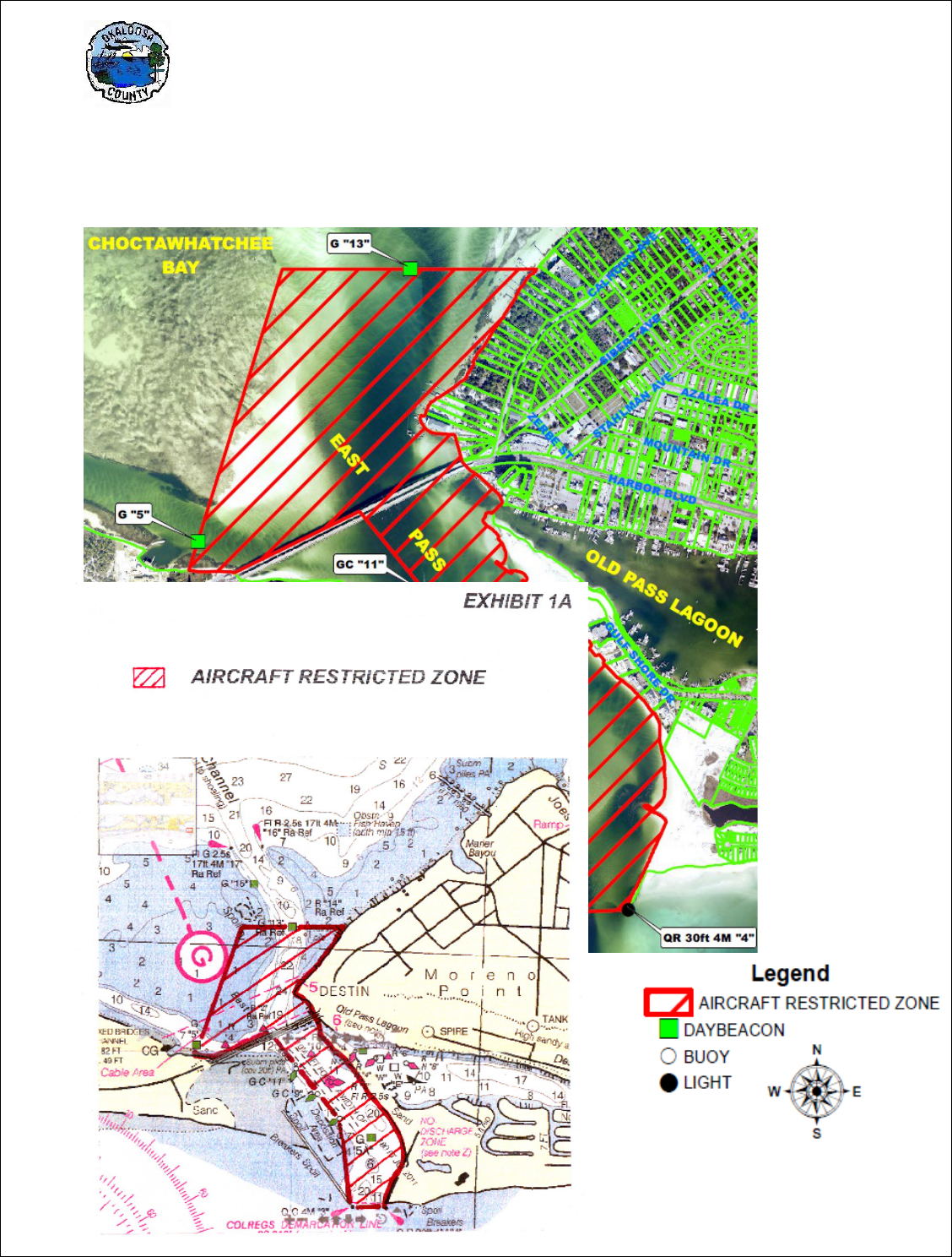
LAND DEVELOPMENT CODE Chapter 2
Zoning Regulations
____________________________________________________________________________________
2-69
section apply to publicly or privately owned helicopters serving as ambulances, or search and rescue
vehicles, or when in use for police, fire, or public service or like duties.

LAND DEVELOPMENT CODE Chapter 2
Zoning Regulations
____________________________________________________________________________________
2-70
2.20.10 MEDICAL MARIJUANA
DISPENSARIES
The operation of medical marijuana dispensing facilities or treatment centers
shall
comply
with the following performance
standards:
(1) Dispensing. Dispensing by payment for and receipt of
medical
marijuana
shall only be allowed within the facility of a properly registered
medical
marijuana dispensing facility or treatment center, except that this
provision
shall
not be construed to prohibit delivery to a qualifying patient
or caregiver
registered
with the State of
Florida.
(2) No drive through service or mobile vendor. No medical
marijuana
dispensing facility or treatment center shall have a drive through or drive
in
service
aisle. Medical marijuana shall not be dispensed, paid for and
received via
the
method of mobile vending. All dispensing, payment
for and receipt of
products
shall occur from inside the medical marijuana
dispensing facility or
treatment
center; provided however, this provision
shall not be construed to prohibit
delivery
of medical marijuana to a
qualified patient, as permitted
by
state law or
rule.
(3) On-site consumption of medical marijuana. The consumption
of
medical
marijuana is prohibited within a medical marijuana dispensing facility
or
treatment center, or anywhere on the premises outside of the facility,
including,
but
not limited to the parking areas, sidewalks, or rights-of-way
surrounding the
facility
or
center.
(4) So
le use. The sole use permitted on the premises of any medical marijuana
dispensing facility or treatment center shall be limited to those uses
permitted by Florida law and county regulations. No other goods or services
shall be provided or sold, and no additional activities shall be
conducted
on the
site which are not authorized by this section. As used in this part,
"premises"
may include an individual stall in a multi-tenant commercial building (e.g., a
stall in a strip mall).
(
5) Separation distances. No medical marijuana dispensing facility or treatment
center shall operate within five hundred feet (500') feet of any pre- existing
public or private elementary, middle, or secondary school, located in either
unincorporated or incorporated Okaloosa County. For purposes of this
section, distance shall be determined by measuring a radius from the closest
improved part of the property (excluding stormwater treatment facilities and
landscape buffers) supporting the marijuana dispensing facility or treatment
center
to the nearest parcel of land on which occurs the school. If any portion
of a parcel of land containing a pre-existing school lies within the radius, then
the dispensing facility or treatment center shall be deemed to be within such
distance.

LAND DEVELOPMENT CODE Chapter 2
Zoning Regulations
____________________________________________________________________________________
2-71
(6) Prohibited Activities. Any other activity related to preparation, wholesale
storage, distribution, transfer, cultivation, or processing of any form of
marijuana or marijuana product not specifically authorized by the license
issued by the Florida Department of Health to the dispensing organization
for the subject facility or center.
(7) Business Tax Receipt Requirement: Owners or ownership entities of
medical marijuana dispensing facilities or treatment centers licensed by the
Florida Department of Health, must obtain a Business Tax Receipt from the
Okaloosa County Tax Collector for such use.
(8) Compliance with other laws. Medical marijuana dispensing facilities or
treatment centers shall at all times be in compliance with all applicable state
and local laws and regulations. In the event of a conflict between the
provisions of state law and this Ordinance, then the provisions of state law
shall control.
(9) Enforcement. The provisions of Section 2.20.10 may be enforced by the
Code Enforcement Division of the Okaloosa County Growth Management
Department or by the Okaloosa County
Sheriffs
Office. Nothing herein
shall preclude or limit the ability of the Okaloosa
Sheriffs
Office or any
other law enforcement entity from pursuing any action authorized by law.
2.21.00 ACCESSORY USES AND STRUCTURES
2.21.00 Purpose: Provide guidelines and standards for those uses and structures that may be
customarily incidental or commonly associated with permitted uses as may be appropriate to maintaining
the purpose and integrity of any particular zoning district.
2.21.01 Applicability: Accessory uses and structures are a permitted use on any lot or parcel when such
use is customarily incidental and commonly associated with a principal permitted use as may be specified
in any particular zoning district. A finding of whether or not a use or structure is customarily incidental to
or commonly associated with a permitted use shall be supported by the following:
1. the use is so necessary or commonly to be expected that it cannot be supposed that the zoning
regulations were intended to prevent it, and;
2. consideration of the impact upon the surrounding area and the zoning district involved. Any range
of accessory uses and structures may be permitted when it has been commonly, habitually, and
by long practice established that such uses and structures are reasonably related to, and
associated with, a principal permitted use. The requirements specified herein are not intended to
apply to temporary uses and structures.
2.21.02 Residential Accessory Uses and Structures: The following accessory uses and structures are
considered commonly associated with residential uses.
1. The following are permitted on lots or parcels in R-1, R-2, R-3, SR and MU
zoning districts.
a. Private, freestanding garage or carport;

LAND DEVELOPMENT CODE Chapter 2
Zoning Regulations
____________________________________________________________________________________
2-72
b. Fence (except barbed wire, razor wire, glass-topped or other similar type not commonly
associated with residential use);
c. Storage shed;
d. Freestanding deck, patio;
e. Dock or pier;
f. Swimming pool and enclosure, pool house;
g. Gazebo, cabana;
h. Vegetable or ornamental garden;
i. Playhouse;
j. Television or radio antennae;
k. Keeping of domesticated animals as pets;
l. Guest house;
m. Garage apartment.
n. Home occupation/office;
o. Home or kitchen garden;
p. Other similar uses and structures.
2. The following are permitted as part of an overall residential neighborhood or development and as
part of a mixed use development or multi-family building development in R-1, R-2, R-3, SR
and
MU zoning districts.
a. Recreation areas including playgrounds, fields, courts, trails, etc.;
b. Community center, club house;
c. Community parking area or garage;
d. Vehicle/boat storage area;
e. Maintenance facilities and yards;
f. Security gates, guard house;
g. Docks or piers, private marina;
h. Golf course, including club house, pro shop, and restaurant;
i. Identification and directional signs;
j. Business office;
k. Dumpsters;
l. Home or kitchen garden;
m. Other similar uses and structures.
2.21.03 Nonresidential Accessory Uses and Structures: Commercial accessory uses and structures
commonly associated with commercial, industrial, or institutional permitted uses are permitted in C-1, C-2,
C-3, I-1, I-2, and INST zoning districts as follows.
1. Drive-up/through windows;
2. Automatic tellers, kiosks;
3. Vehicle/equipment storage areas;
4. Dumpsters;
5. Facilities operated primarily for the convenience of employees, clients, or customers of a
permitted principal use which is operated as an integral part of such use and does not create a
separate business or commercial activity;

LAND DEVELOPMENT CODE Chapter 2
Zoning Regulations
____________________________________________________________________________________
2-73
6. Home or kitchen garden;
7. Other similar uses and structures.
2.21.04 Agriculture Accessory Uses and Structures: Agriculture accessory uses and structures
commonly associated with agricultural permitted uses are permitted in the AA
zoning district as follows.
1. General Agriculture: Barn; stable; keeping farm animals, livestock, poultry, bees
(see paragraph
10); produce/vegetable stand; equipment and storage shed; silo; windmill; fuel tank; water tank;
poultry house; animal pen; irrigation devices, and; other similar uses.
2. Conservation, Outdoor Recreation, Public/Institutional: Uses and structures commonly associated
with these permitted uses.
2.21.05 Limitations and Restrictions: Permitted accessory uses and structures shall be subject to the
following limitations and restrictions.
1. No accessory use or structure shall be installed, constructed, or placed so as to prevent the safe
use of any driveway, or to cause a vision obstruction in any intersection vision triangle, or
otherwise create a hazard by obstructing the view of pedestrians, cyclists, or motorists.
2. Accessory uses or structures located in side or rear yards shall be no closer than five (5) feet to
any property line, except as otherwise specified herein.
3. Accessory uses and structures located in front yards must conform to the front minimum building
setback requirement for the zoning district in which it is located, except as otherwise specified
herein.
4. Fences: Fences are permitted in any zoning district subject to the following restrictions.
a. Fences may be installed or constructed along or within any property line.
b. Fences must be constructed using customary fencing materials such as wood, metal,
wire, or masonry.
c. Use of barbed wire, razor wire, or chicken wire is prohibited in residential districts.
d. Fences shall not exceed eight (8) feet in height.
e. No fence shall be placed across any public right-of-way or public easement unless
permission isvgranted by the agency of jurisdiction.
f. Certain uses may be subject to state fencing laws including, but not be limited to: game
preserves (s. 379.302, F.S.); open pits (s. 768.10
, F.S.); waste disposal (s. 62-701, FAC);
junkyards (s. 339.241, F.S.); swimming pools (Ch. 515, F.S.); livestock fences (Ch. 588,
F.S.).
5. Dumpsters: Dumpsters are permitted in all zoning districts except R-1 and R-2
subject to the
following restrictions.
a. Temporary construction dumpsters are permitted in R-1 and R-2
zoning districts.

LAND DEVELOPMENT CODE Chapter 2
Zoning Regulations
____________________________________________________________________________________
2-74
b. Dumpsters may be located on single-family, detached dwelling unit lots for construction
purposes only. The dumpster(s) must be removed upon completion of construction.
c. All dumpsters must be screened from view of adjoining property owners and streets at
first floor level. Dumpsters shall be screened on at least three (3) sides. Temporary
construction and demolition debris dumpsters are exempted from the screening
requirement.
d. All dumpsters shall be located off the public right-of-way, on a paved pad or hard surface
and vehicular access shall be paved or improved with a stable surface.
e. The following structures may be permitted as screening for dumpsters.
i. Wood Fence.
ii. Concrete block and stucco wall, masonry wall, brick wall, or walls of similar
material.
iii. Vegetative screening shall comply with Section 6.05.07
.
f. Dumpsters may be permitted within the building setback area provided there is no
obstruction of vision of adjacent streets.
g. Screening for dumpsters shall be exempted from height limitations for fences provided
there is no obstruction of vision of adjacent streets.
h. Screening of dumpsters shall be exempted in the Industrial Protected (IP) Zoning District
if the dumpsters are located greater than two hundred feet (200) from residentially zoned
or used property and are not located within front yards, Agricultural Districts, or during
construction in all other zoning districts.
6. Guest House/Garage Apartment: Guest houses and garage apartments are permitted in all
zoning districts subject to the following restrictions.
a. No more than one guest house shall be permitted on any lot or parcel.
b. Guest houses are to be detached from the principal dwelling unit but may be connected
by a covered walkway.
c. The guest house shall not exceed the total square footage of the principal structure
located on the lot.
7. Storage Sheds: Storage sheds are permitted in all zoning districts subject to the following
restrictions.
a. Storage sheds must be located in side or rear yards in any residential zoning district.
b. Vehicles, recreational vehicles, manufactured homes, mobile homes or truck trailers shall
not be used as storage sheds.

LAND DEVELOPMENT CODE Chapter 2
Zoning Regulations
____________________________________________________________________________________
2-75
8. Swimming Pools: Swimming pools and associated enclosures are permitted in any zoning district.
All swimming pools must be located and constructed in compliance with applicable law including
the Florida Statue
Ch. 515, F.S. and the Florida Building Code, Ch. 41 (Residential) and Ch. 424
(Commercial).
9. Home Occupation:
The standards for home occupations are intended to ensure compatibility
with other permitted uses and with the residential character of the neighborhood. No home
occupation shall be permitted which might interfere with the general welfare of the
surrounding area due to potential noise, increased pedestrian or vehicular traffic or might
entail any other condition which would constitute an objectionable use of residential property.
Home occupations shall be allowed in any zoning district which permits residential dwellings
as a principal permitted use or as a special exception use, provided the following criteria are
met upon review by the planning staff:
a. Criteria
I. Up to two (2) non-residents and family residing on the
premises shall be engaged in such occupation.
II. The business shall be "secondary” to the residential use.
III. There shall be no change in the outside appearance of the
building or premises, or other visible evidence of the conduct
of such home occupation, including outside storage or
accessory buildings, other than one sign, not exceeding two
square feet in area, non-illuminated, and
mounted flat against
the wall of the principal building. Outside storage or
accessory
structures may be used for "incidental uses" associated with
the business.
IV. Any need for parking generated by the conduct of such home
occupation shall be improved; while parking in the right-of-way
shall be prohibited.
V. No equipment or process shall be used in the home
occupation which creates noise, vibration, glare, fumes, or
odors detectable to the normal senses off the premises of the
dwelling unit.
VI. No equipment or process shall be used which creates visual
and/or audible interference in any radio or television receiver, or
causes fluctuations in the line voltage off the premises of the
dwelling unit.
b. Application
i. An application for a home occupation shall be made to the Planning and
Inspection Department for a determination of compliance with the criteria set
forth in Section a. prior to obtaining a license from the Tax Collector’s Office
(refer to Chapter 12 for the home occupation application fee).

LAND DEVELOPMENT CODE Chapter 2
Zoning Regulations
____________________________________________________________________________________
2-76
ii. Applicant must sign a notarized affidavit, agreeing to continue to comply with all
criteria contained in Section a, and acknowledge that any departure from t
he
c
onditions authorizing the use shall be grounds for revocation of the applicabl
e
oc
cupational license, without refund of application fee, and forfeit their right t
o
c
ontinue the home occupation at the permitted site.
iii. When a nuisance complaint is received, an inspection shall be made to ensure
c
ompliance with this chapter. If lack of compliance is evident, the permittee shall
be given thirty (30) days in which to comply or cease operation at the permitt
ed
s
ite
.
10. Livestock; Poultry; Beekeeping: The keeping or harboring of livestock, poultry, or
honeybees is permitted only as specified herein. “Livestock” includes all animals of the equine,
bovine, or swine class including goats, sheep, mules, horses, hogs, cattle, ostriches, and
other grazing animals. “Poultry” means all kinds of poultry and includes chickens, turkeys,
ducks, guineas, geese, pigeons raised as domesticated food birds,
quail, and other domesticated food birds. “Beekeeping” means maintaining a site or location
where honeybee hives, frames, supers pallets, queen excluders, and/or other such equipment used
in the cultivation of honeybees and the harvesting of products produced
by honeybees.
a. Livestock. The keeping or harboring of livestock is not considered customarily
incidental to residential uses of property and is prohibited in the R-1, R-2, and R-3 zoning
districts unless approved by special exception as provided in d, below.
b. Poultry. The keeping of poultry is permissible as a principal use in the AA and RR zoning
districts. The keeping of poultry is allowed as an accessory use on lots with
an existing land use of single family residential, regardless of current zoning or Future
Land Use Map designation in accordance with the following:
i. Poultry shall mean chickens (Gallus gallus domesticus) and domesticated ducks
(Anas platyrhynchos domesticus - Pekins and Indian runner ducks only)
ii. Roosters are prohibited except in the AA and RR zoning districts
iii.
The minimum lot size shall be no less than one-fifth of an acre, and no more
than four (4) chickens shall be allowed for the first fifth of an acre and three
(3) additional chickens allowed per each additional fifth acre (areas less than
one-fifth of an acre will not qualify for additional chickens) on each respective
property with an existing land use of single family residential.
iv. Poultry must be kept in an enclosed structure at night (coops, hen houses, etc.).
v. Coops or enclosures housing poultry shall be located:
a) in the rear yard behind the dwelling unit
b) at least twenty-five (25) feet from the door or window of any other dwelling
or occupied structure other than the owner's dwelling
c) outside of the applicable district's accessory structure setback areas

LAND DEVELOPMENT CODE Chapter 2
Zoning Regulations
____________________________________________________________________________________
2-77
vi. All items such as feed that may attract rodents or other wildlife shall be kept in
rodent/pest proof containers.
vii. If poultry are allowed to free range, the free-ranging area must be secured such
that the poultry cannot leave the rear yard of the subject property, including by
flight.
viii. If ducks are kept, they shall be provided a wading pool (a children's "kiddie pool"
with a minimum radius of no less than 48 inches will suffice) which must be
maintained with clean, fresh water.
ix. There shall be no odors associated with the keeping of poultry discernible at the
property lines.
c. Beekeeping. Beekeeping shall be allowed as authorized and regulated by the
State of Florida.
d. The requirements herein shall not apply to the keeping and raising of household
pets. “Pet” means any animal kept for companionship or amusement rather than
utility, burden, or associated with food products or food production, and which is
not otherwise regulated by this code and which is not classified by the Florida Fish
and Wildlife Conservation Commission (FWC) as a Class I or Class II wildlife
species, a Class III Wildlife Species not exempt from FWC permitting, a
Conditional Non-native Wildlife species, or a venomous reptile.
11. Home or Kitchen Garden: Gardens for the growing of fruits and vegetables for personal or
household food consumption are allowed in any zoning district, this includes areas that may be
used for “community gardens” or “urban farms.”
